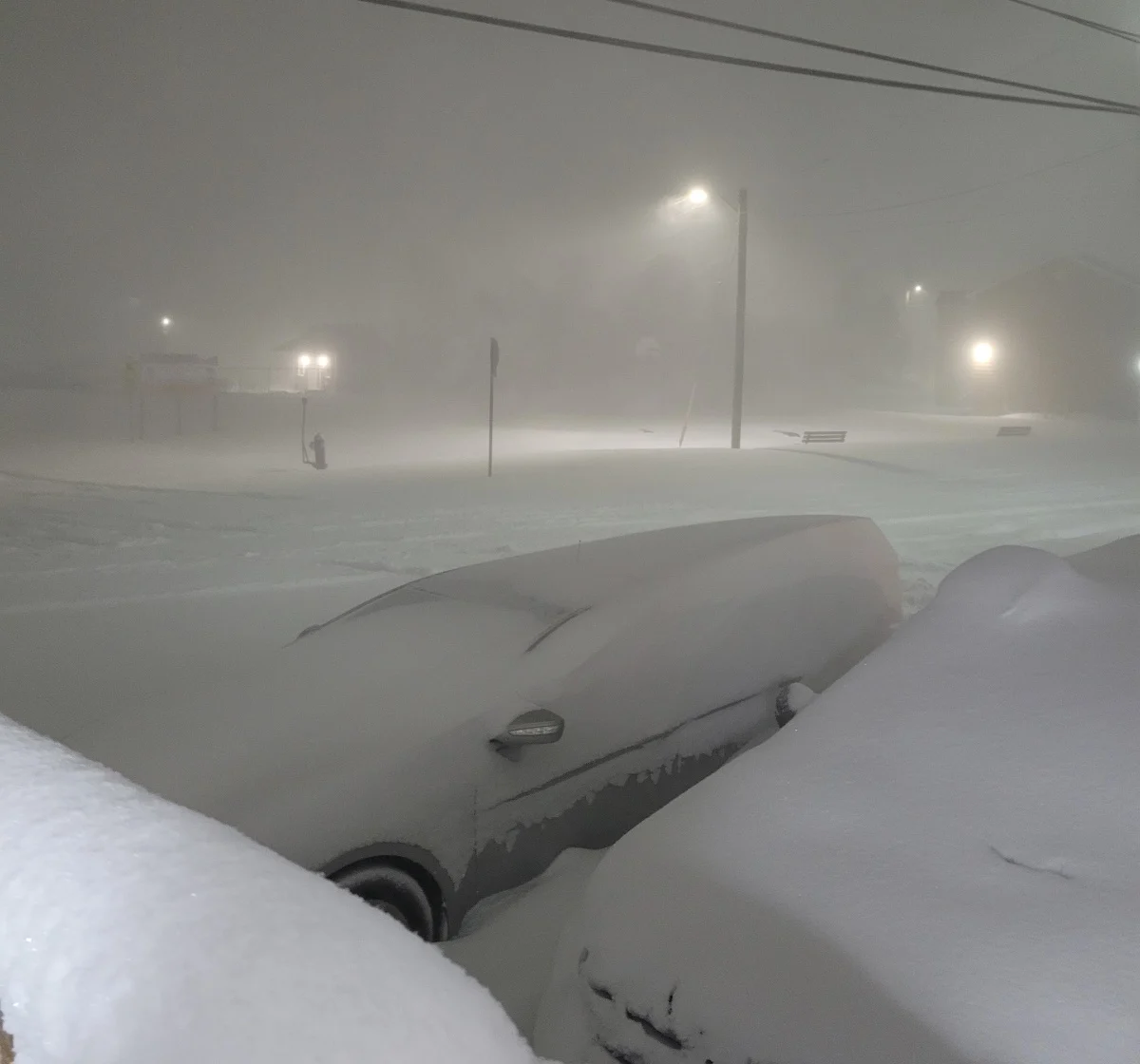
Blizzard conditions likely as weather bomb closes in on Atlantic Canada

Winter storm warnings cover more than 45 million people from North Carolina to Newfoundland this evening as a powerful weather bomb develops off the U.S. East Coast. This intense winter storm will bring heavy snow, high winds, significant ice, and driving rains to all of Atlantic Canada through Sunday. Blizzard conditions are likely for many areas during the height of the storm. A province-by-province breakdown of what you need to know, below.
DON’T MISS: Here's how to stock your vehicle's emergency kit, BEFORE you get stranded
FRIDAY NIGHT: THE STORM DEVELOPS OFF THE U.S. EAST COAST
Atlantic Canada’s winter storm will first take aim at the U.S. East Coast. The low-pressure system responsible for all the action will rapidly intensify as it passes the Delmarva Peninsula and approaches New England.
Blizzard warnings and winter storm warnings cover a vast stretch of the eastern seaboard, including major population centres such as Philadelphia, New York City, and Boston. A blizzard warning is in effect for all of the Boston metro, where the U.S. National Weather Service warns residents could see more than 60 cm of wind-driven snow by the end of the storm.
MUST SEE: Winter storm to blast U.S. Northeast with blizzard-like conditions
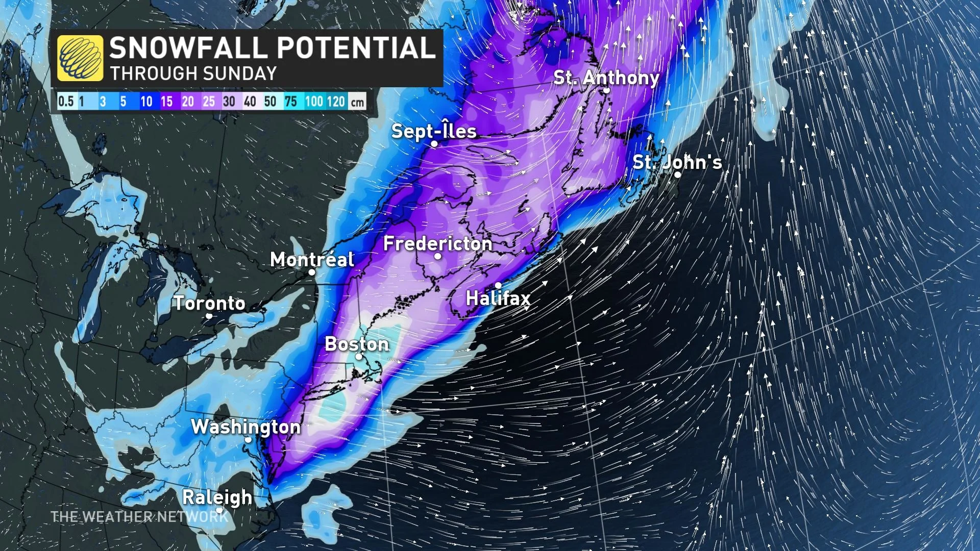
This is the mess that’s on its way to Atlantic Canada this weekend. The sprawling system’s precipitation will begin to arrive in the Maritimes early Saturday morning, spreading across the region throughout the day. High winds resulting from the storm’s swift strengthening will accompany the precipitation across the region.
This storm's size and wide temperature spread means we’ll see the whole spectrum of wintry precipitation across the region, with heavy snow, ice pellets, freezing rain, and rain along the track of the storm. Widespread winter storm warnings and special weather statements are in effect, with each province experiencing the system differently. Here’s a breakdown of what you can expect.
NEW BRUNSWICK AND PRINCE EDWARD ISLAND: HEAVY SNOW, SOME ICE MIXES IN ACROSS P.E.I.
New Brunswick will remain to the west of the storm’s track, meaning the province will likely remain all-snow for the duration of the storm. As such, the highest snowfall totals are possible across southern New Brunswick, including Fredericton, Moncton, and Saint John, where winter storm warnings are in effect. These areas could see 20-30+ cm of snow by the end of the storm.
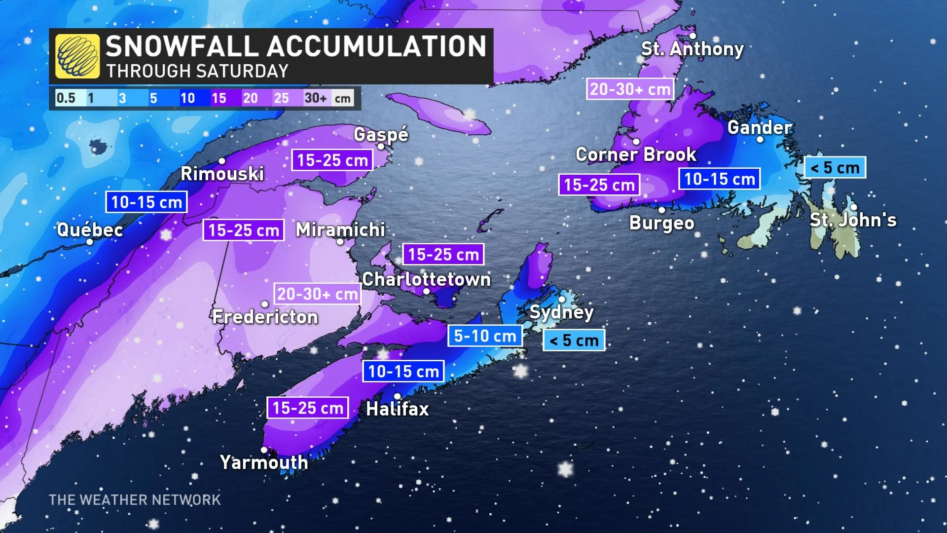
It’ll be a similar story across the strait on Prince Edward Island, where 15-30 cm of wind-driven snow is possible by the end of the storm. Warm air aloft will become a factor for P.E.I. as the centre of the storm crosses the province and changes the snow over to ice pellets and freezing rain. We’re likely to see a snowfall gradient across the island, with Tignish and Summerside potentially notching higher snowfall totals than Charlottetown and Souris.
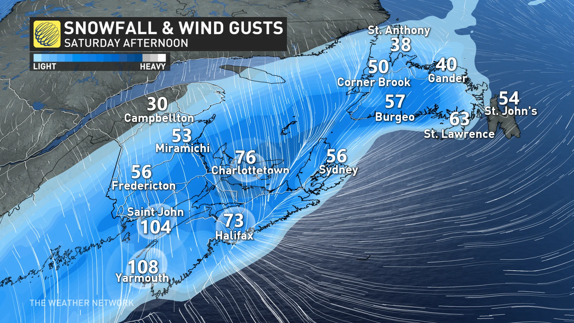
High winds, potentially gusting as high as 100 km/h at times, will lead to extended periods of whiteout or near-whiteout conditions during the height of the storm.
Stay indoors and avoid travel during periods of low visibility. It’s very easy to become disoriented in blowing snow, even if you’re close to home on your own property.
Snow will slowly draw to an end Sunday morning as the storm pulls away toward the Gulf of St. Lawrence.
WATCH: WHAT, EXACTLY, IS A 'WEATHER BOMB'?
NOVA SCOTIA: A SLOPPY MIX OF SNOW, ICE, AND RAIN IS LIKELY
The track of this major winter storm will leave Nova Scotia in that uncomfortable position where all precipitation types are possible.
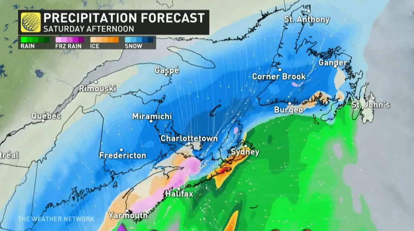
Precipitation that begins as snow will likely change over to ice pellets and freezing rain as the centre of the storm draws closer during the day on Saturday. Warm air will change precipitation over to all rain for areas including Halifax and Cape Breton Saturday afternoon.
Across the rest of the province, the eventual changeover to ice and rain will keep totals lower, with about 10-20 cm of snow expected around Halifax and even lower totals likely up toward Cape Breton.
Stay aware of the risk for coastal flooding during the storm, as well. Persistent high winds could push a minor storm surge into vulnerable stretches of coastline across Nova Scotia.
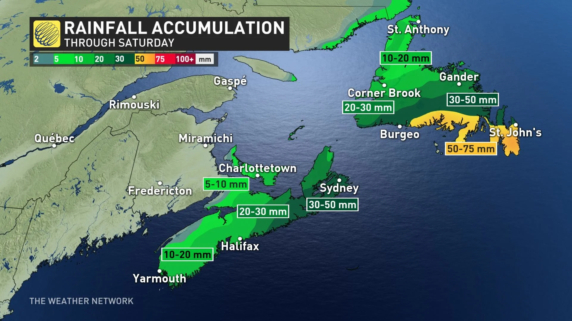
NEWFOUNDLAND: MOSTLY SNOW IN THE WEST, MOSTLY RAIN IN THE EAST
The bulk of the Atlantic’s storm will reach Newfoundland later in the day Saturday and last into Sunday afternoon for much of the island. Precipitation starts as snow Saturday evening - quickly accumulating between 15-30 cm - and spreads northward through the night. As the snow lifts northward and warmer air pushes in, there will be a transition to freezing rain before changing to rain by Sunday morning.
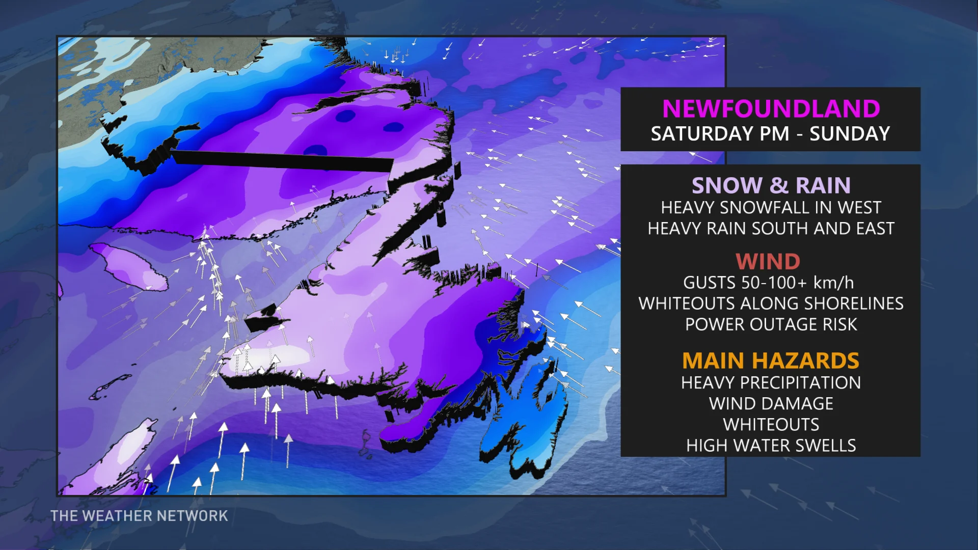
Most folks in Newfoundland will find themselves on the warm side of this storm, with less than 5 cm of snow possible on the Avalon Peninsula before we change over to a cold rain. During this transition, central Newfoundland could see freezing rain and ice pellets.
Rainfall totals have trended higher, with as much as 40-70 mm expected across the Avalon and Burin Peninsulas. The northern Avalon (including St. John's) will end up toward the lower end, while the Burin and southern Avalon are likely to be on the higher end of the range.
As the system departs, residents across western Newfoundland can expect a quick shot of snow.
Blizzard warnings are in effect for the Great Northern Peninsula, including St. Anthony, as well as eastern portions of Labrador. High winds and heavy snowfall could lead to near-zero visibility at times across these areas.
STAY SAFE: PREPARE FOR HIGH WINDS AND POWER OUTAGES
The impending storm’s high winds and heavy snow and ice could cause damage to trees and power lines. Make sure to secure or remove any loose objects that could blow around during gusty winds. Remain mindful of trees or tree limbs that could fall during the storm.
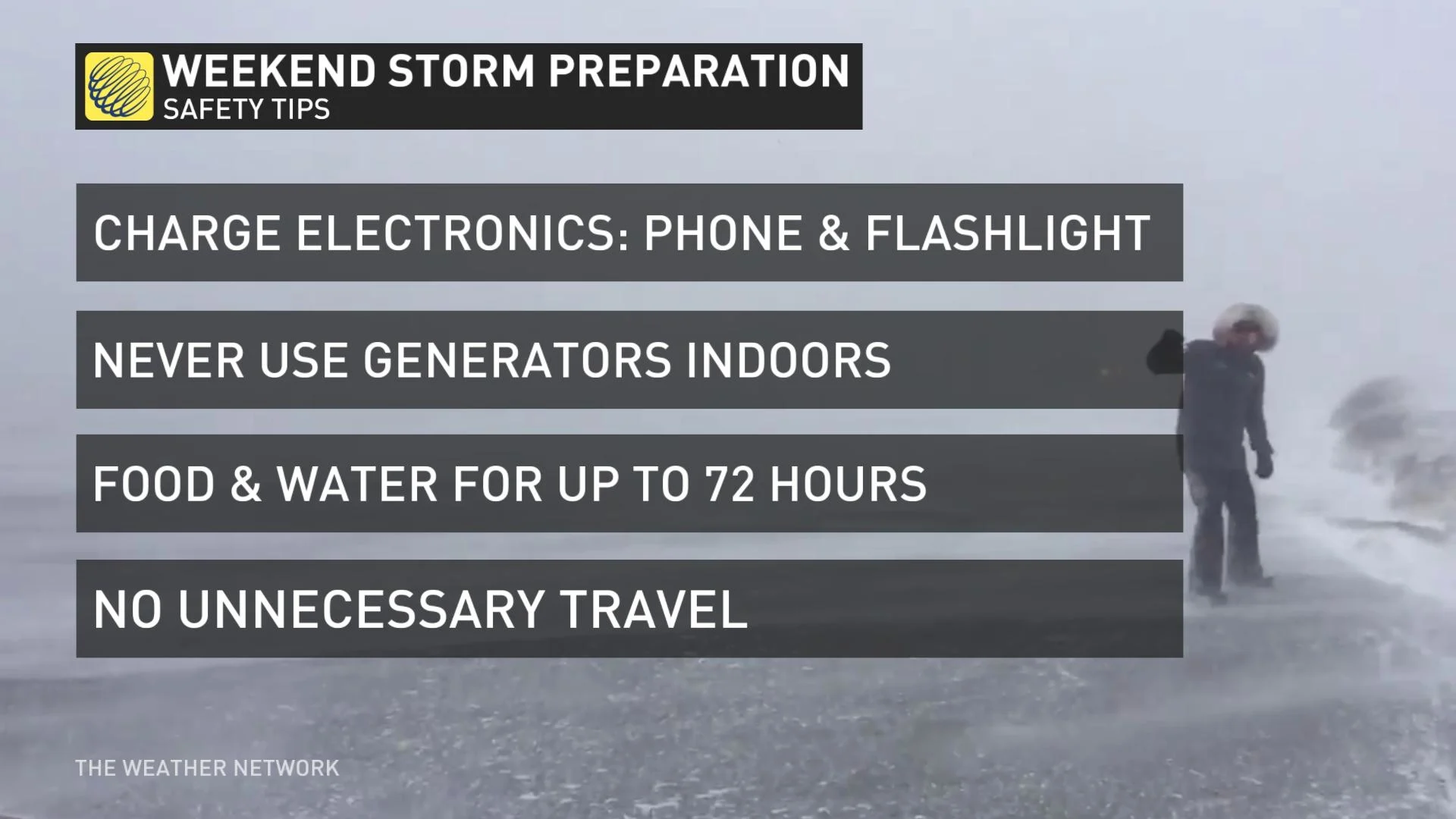
The combination of heavy snow and high winds could lead to scattered power outages this weekend. It’s a good idea to prepare now for potential power outages.
Make sure you have ready-to-eat food if you can’t cook during a power outage. Charge up mobile devices before the storm arrives and keep a rechargeable battery pack on hand to juice up your device when needed. Dig out flashlights and fresh batteries so you don’t have to strain your cell phone battery looking around in the dark.
Stay tuned to The Weather Network for all the latest on this major winter storm.


