
Quickly accumulating snow, difficult travel hits Ontario

Rounds of unsettled weather will see out the month of February across southern Ontario, starting with some widespread nuisance snow on Monday.
The start to the week was quite messy in southern Ontario, with early Monday morning snow causing some difficult travel that led to numerous reports of collisions. Conditions will be similar Tuesday, courtesy of another weak system, though not as impactful, with just a dusting of snow -- perhaps 3-5 cm in the south and even less for the Golden Horseshoe. Temperatures will continue to climb this week, with Wednesday possibly featuring daytime highs the warmest since December. This will also be greeted with yet another weak clipper tracking in with 5-10 cm of snow for cottage country, but mixing and/or rain for the GTA and areas near Lake Ontario shorelines. More on the timing and impact for this final week of February, below.
WEATHER HIGHLIGHTS:
Unsettled weather continues for the first half of the week
Next chance of snow comes Tuesday morning, tricky travel possible
Turning colder end, but near seasonal end of week, possibly messy weekend system
TUESDAY: WEAK SYSTEM BRINGS ANOTHER SHOT OF SNOW
A trough will swing through southern Ontario Tuesday morning, but its impacts be much less for the region than what was seen Monday. The Golden Horseshoe is expected to see minimal amounts, perhaps 2 cm or less, with 3-5 cm elsewhere in the south.
Roads could still be impacted by the quick burst, so motorists should be wary of the morning commute as conditions could be slippery.
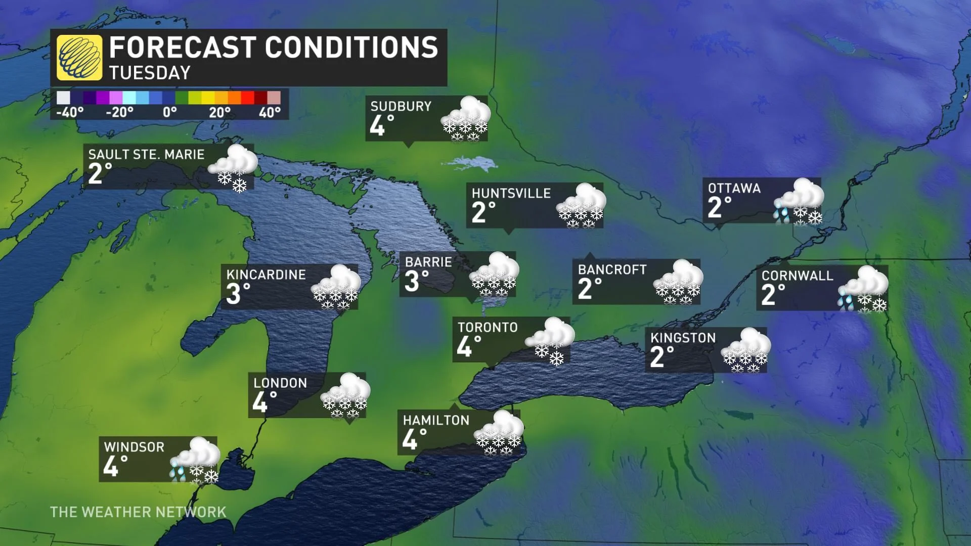
Temperatures will remain above freezing once more, with daytime highs into the low single digits. Wednesday will see the rise in temperatures continue.
WEEKLY OUTLOOK: REMAINING UNSETTLED WITH MULTIPLE SYSTEMS, MILDER TEMPERATURES
Another clipper will track across the central Great Lakes and Ontario on Wednesday with 5-10 cm of snow across cottage country and parts of the Ottawa Valley. It will be a very mild day across southern Ontario -- possibly the warmest temperatures since December.
This means the GTA will likely just see mixing or rain, especially along shorelines of Lake Ontario. Snow should remain north of the GTA. Travellers in the region can expected ponding on the roads, however, due to the melting snowpack from the mild temperatures.
Again, a weak system will bring snow-showers to southern Ontario on Thursday evening. Temperatures will also turn colder, but near seasonal, for the end of the week.
A messy system is possible this weekend, but still too early to have confidence in storm track and impacts, but southern areas are at risk to see a changeover to ice and rain.
Be sure to check back for the latest updates on the weekend system that threatens Ontario.