Nova Scotia’s historic rains would’ve smashed records in Florida

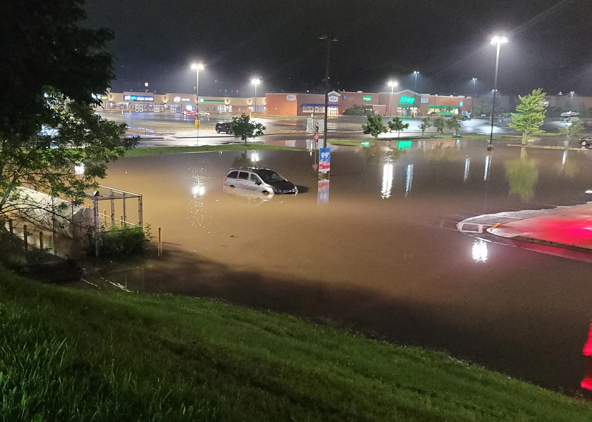
Tropical downpours unleashed significant flash flooding across the Halifax area on Friday, a deluge that would've eclipsed rainfall records even down in Florida
An entire summer’s worth of rain fell in just a couple of hours on Friday, July 21, as an unprecedented deluge swept over southern Nova Scotia.
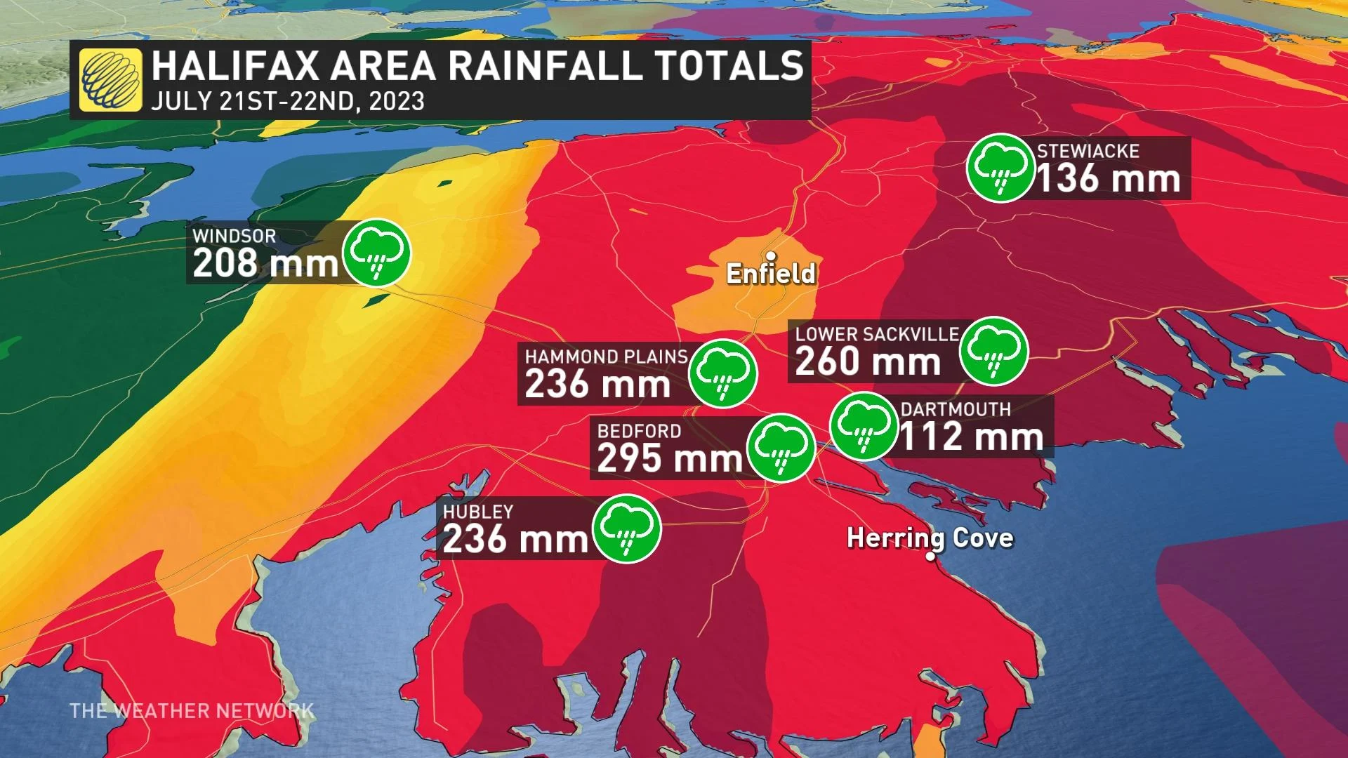
Parts of the Halifax Regional Municipality recorded more than 200 mm of rain during the prolific thunderstorms that persisted through the afternoon and evening hours.
SEE ALSO: Record flooding in Nova Scotia leads to four missing people, state of emergency
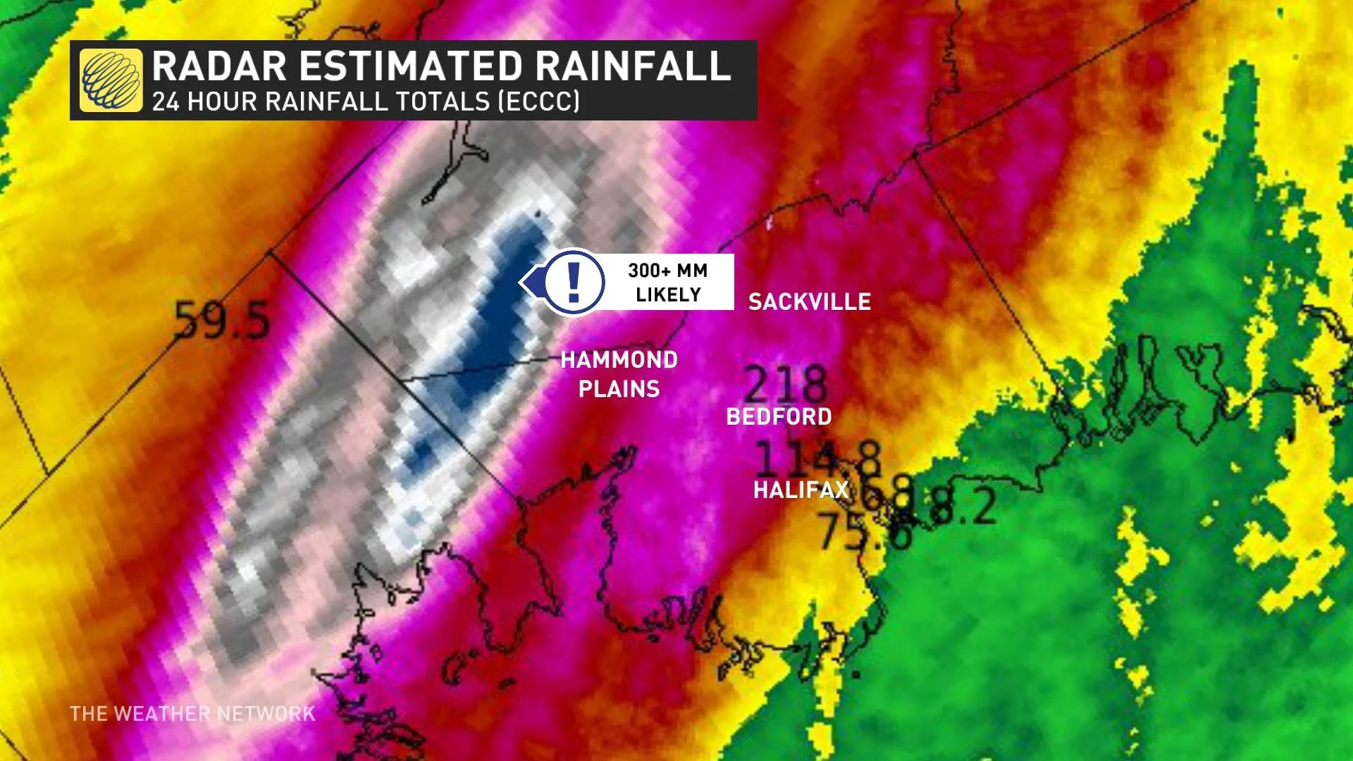
Doppler radar estimates showed more than 300 mm of rain falling north and west of Halifax proper, covering many of the areas devastated by wildfires in late May and early June. Wildfire scars can exacerbate flooding as a result of the damaged soils.
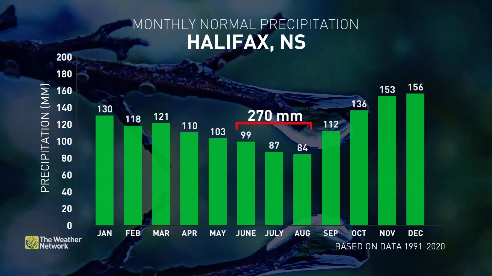
For communities hardest hit by the recent deluge, this event likely dropped more rain in one afternoon than the region typically measures during an entire summer. The average summertime rainfall in Halifax comes in around 270 mm.
Nova Scotia eclipsed some of Florida’s heaviest rainstorms
Friday’s rains were not only an unprecedented event in Nova Scotia, but it was likely a top-tier rainfall event in the recorded history of any major Canadian metropolitan area.
More than 200 mm of rain falling in just four or five hours would be a remarkable feat for subtropical cities down in the United States, let alone for the Canadian Maritimes.
The rains that hit Nova Scotia on Friday would’ve caused major flooding even down in Florida, where waterways and drainage systems are equipped to handle regular downpours.
Friday's deluge would have easily eclipsed the most rain ever recorded in Orlando, Florida, in a single day. If you’ve ever been to central Florida’s theme parks on vacation during the summer, you know that the region’s near-daily thunderstorms mean business.
Orlando International Airport measured 196 mm of rain on September 28, 2022, making for the city’s wettest day ever recorded.
The torrential downpours near Halifax would have even caused problems all the way down in Miami, where radar estimates of 300 mm northwest of Halifax would’ve made for the fourth-largest single day rainfall in Miami’s lengthy history.
WATCH: Radar animation shows thunderstorms training over the Halifax area
Deep plumes of tropical moisture responsible for the deluge
A deeply tropical airmass flowing over the Maritimes was responsible for the historic rains that hit southern Nova Scotia on July 21.
The region has stewed in historic levels of heat and humidity in recent days, with all-time high humidex values recorded in Truro, Nova Scotia; Moncton, New Brunswick; and Gander and Bonavista in Newfoundland.

Day after day of warm temperatures and soupy humidity set the stage for the historic rains that hit southern Nova Scotia on July 21.
A formidable plume of tropical moisture funneling into the Maritimes from the south supplied the thunderstorms with all the moisture they needed to produce torrential downpours.
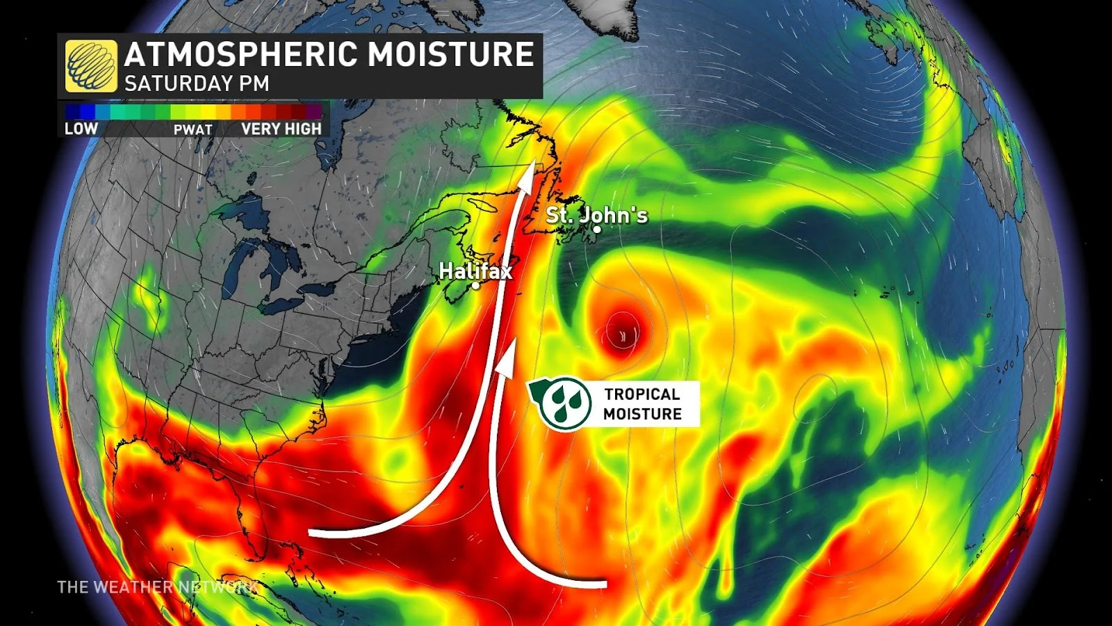
This enhanced moisture acted like a reservoir for the storms to tap into, allowing them to efficiently wring out copious amounts of water that drenched communities for hours at a time.
Scattered thunderstorms feeding off that moisture would’ve been manageable for a short time, but Friday’s thunderstorms repeatedly developed and moved over the same areas like train cars on railroad tracks. This created a classic “training” storm setup that’s responsible for some of the most intense flash flooding possible.
Thumbnail image courtesy of Colleen in Lower Sackville, N.S.