'Catastrophic' Hurricane Dorian devastates Bahamas, nears Florida
Five U.S. states have declared emergencies and issued evacuation orders as the slow-moving storm inches toward the U.S. mainland.
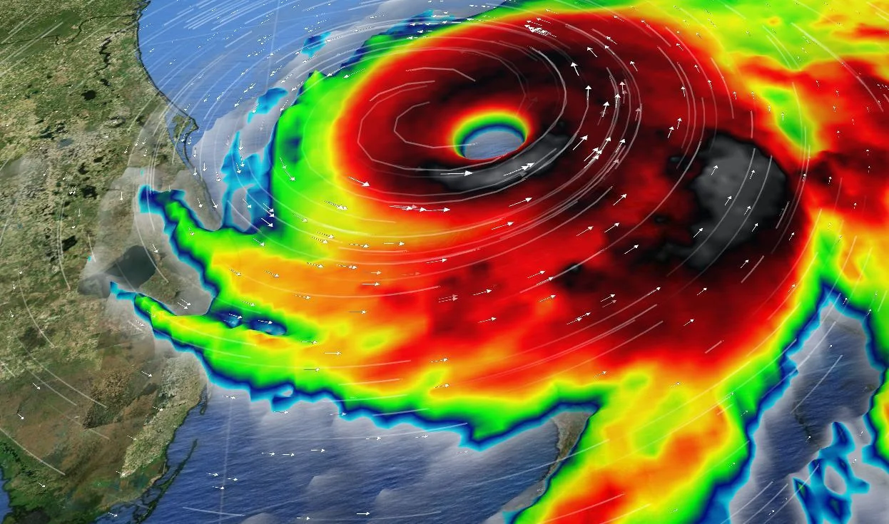
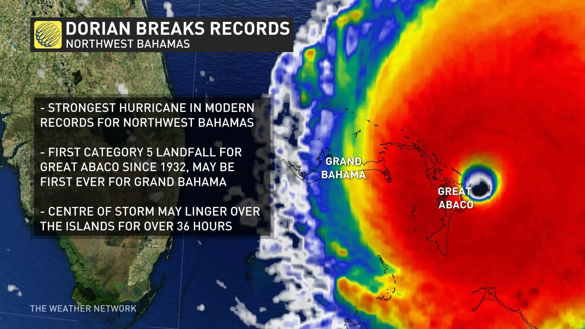
Hurricane Dorian was still a Category 5 monster early Monday morning as it continued to devastate the Bahamas, and though it weakened slightly to Category 4 as the day wore on, the worst is far from over.
The storm made landfall at Elbow Cay on Great Abaco Island at 12:40 p.m. EDT Sunday, and made a second landfall on Grand Bahama several hours later. By late Monday morning, its wind speeds had fallen slightly to 250 km/h, still an 'extremely dangerous' Category 4 storm.
WATCH BELOW: DEVASTATING FLOODING AT GRAND BAHAMA INTERNATIONAL AIRPORT
Presently, the storm is set to track westward or northwestward for at least the next day before a slow turn to the northeast. However, it is moving extremely slowly, around 2 km/h, making its effects on the Bahamas even more devastating.
"On this track, the core of extremely dangerous Hurricane Dorian will continue to pound Grand Bahama Island through much of today and tonight," the U.S. National Hurricane Center says. "The hurricane will then move dangerously close to the Florida east coast late tonight through Wednesday evening and then move dangerously close to the Georgia and South Carolina coasts on Wednesday night and Thursday."
WATCH BELOW: A LOOK AT HOW FLORIDA IS PREPARING FOR DORIAN
At least one person has been killed as a result of Dorian's impact on the Bahamas. Eyewitness News reported an eight-year-old boy was found dead, likely drowned. Another child is also missing.
It is still too early to know the full extent of the damage, but the Red Cross said in a statement as many as 13,000 homes may have been damaged or destroyed by the storm so far.
Storm surge on Grand Abaco has been so extreme that “you cannot tell the difference as to the beginning of the street versus where the ocean begins," Bahamanian Prime Minister Hubert Minnis told a press conference Sunday.

Though water levels are expected to slowly subside on Grand Abaco, people in Grand Bahama will be grappling with storm surge as much as 7 metres above normal, as well as those extreme winds and extreme rainfall of hundreds of millimetres that will make flash flooding even more likely.
The Canadian government has issued several travel advisories due to the impacts of Dorian. Canadians are urged to avoid all travel to the Bahamas and all non-essential travel to Florida.
WATCH BELOW: CATASTROPHIC DAMAGE CAUSED IN THE BAHAMAS FROM HURRICANE DORIAN
In the U.S., rainfall amounts will be significantly lower in comparison to the Bahamas, with 50 to 100 mm expected for the Atlantic coast from the Florida peninsula through Georgia. Isolated areas could see as much as 150 mm.

In Florida, hurricane warnings were issued for Jupiter Inlet to the Volusia/Brevard County Line, and watches in effect for north of Deerfield Beach to Jupiter Inlet, and the Volusia/Brevard County Line to the Mouth of the St. Mary's River.
In Florida, a state of emergency was declared last week due to the expected dangerous surf, damaging winds, and potential for life-threatening flash floods. South Carolina, North Carolina and Georgia have also declared emergencies.
A mandatory evacuation was ordered for Brevard County’s barrier Island and is set to take effect at 8 a.m. on Monday as Dorian approaches. A state of emergency is also in effect for North Carolina, South Carolina and Georgia.
WATCH BELOW: DORIAN'S U.S. IMPACT DAY-BY-DAY
Some coastal evacuations have also been ordered in those states. In South Carolina, Gov. Henry McMaster's evacuation order covers the state's entire coast, affecting some 830,000 people according to the L.A. Times.
“We can’t make everybody happy, but we believe we can keep everyone alive,” McMaster said at a press conference.

The Weather Network's Mark Robinson and Jaclyn Whittal, along with storm chaser George Kourounis, will be in Florida this weekend to capture the impacts of Hurricane Dorian as it approaches and makes landfall. Follow them on Twitter as they post live updates.
SEE ALSO: Wildlife center seeks foster homes for hundreds of animals ahead of Dorian
UNCERTAINTY OVER FORECAST TRACK REMAINS
There is still some uncertainty in Dorian’s forecast track. Some of the possible forecast scenarios include Dorian tracking towards the coast of Florida and remaining off the coast as it turns northward or, alternatively, another track that is further offshore.
At this point, there is increasing confidence that Dorian will remain offshore and skim the coast. However, a track under 80 km from the Florida coast will still mean significant impacts to the state, and some potential for a landfall for the Carolinas by later this week.
WATCH BELOW: POTENTIAL PATH OF HURRICANE DORIAN
Why isn't this a straightforward forecast? Dorian's track relies on several factors including the position of the high-pressure system over the Atlantic Ocean, just off the U.S. east coast.
This high-pressure system essentially controls the track of Hurricane Dorian and subtle position and strength changes in that high-pressure system will result in slight shifts to Dorian's path. A trough, meanwhile, will help to steer Dorian northeastward mid-week, and this feature will be important to watch for with regards to impacts on the Carolinas.
Due to the fact that we don't know exactly what path Dorian will take, it is important that anyone along the U.S. southeast coast from Florida to the Carolinas continue to monitor forecasts closely. Forecasters are confident Dorian will remain a major hurricane through the coming days.


