Rainfall warnings issued in B.C., up to 100 mm possible in Vancouver
Heavy rain is ahead for at least the next seven days, along with 1-2 metres of snow for the province's alpine levels.
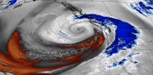
Rainfall and snowfall warnings have been issued as yet another frontal system hits the B.C. coasts with rain and heavy snow at the higher elevations. Some areas could see 24-hour totals of 80-100+ mm and 15-20 cm, respectively. Over the next seven days, western Vancouver Island may see 200-300 mm of rain, with locally higher amounts possible, while the mountain passes could receive a whopping 1-2+ metres of snow, making travel quite difficult. More details, below.
WEATHER HIGHLIGHTS:
Rain for Vancouver Island and Lower Mainland continues, as well as heavy snow in the mountains
Yet another low-pressure system makes its way to B.C. on Saturday
WEEKEND: HEAVY RAIN, SNOW CONTINUE
The New Year is off to a soggy start in B.C. due to the relentless parade of low pressure systems targeting the region. A pair of Pacific frontal systems will track into the province this weekend and will bring drenching rains to coastal regions. Environment Canada has issued numerous rainfall warnings for several areas, including Metro Vancouver, West Vancouver Island, Howe Sound, and the North Coast.

The rainfall warnings say that the rainfall will be heavy at times throughout Saturday and total rainfall amounts over 100 mm are possible, which could cause localized flooding in low-lying areas.
Snowfall warnings for inland areas state that 15-25 cm is possible by Saturday morning. “A frontal system moving across BC today is giving snow to the Coquihalla Highway from Hope to Merritt and to Highway 3 - Hope to Princeton via the Allison Pass,” Environment Canada states.

Another round of heavy rain and snow is expected this weekend, with the potential for two rounds of significant snow for the southern Interior.
Once the rain and alpine snow depart Saturday morning, the next low pushes in the afternoon hours, expected to be the strongest of the forthcoming systems. This will likely be a washout for the day, as the low will bring heavy rain to coastal areas and heavy snow for the mountain passes. Some snow is likely for the Interior, as well.

In all, this active pattern looks to continue well into next week at least. Seven-day rain totals of 75-125+ mm are expected for the South Coast with 50-75 mm for Victoria, and 200-300 mm for the western Vancouver Island, locally higher.
Freezing levels will fluctuate from 800-1,200 metres for the next few days, as well, allowing regular shots of snow from these systems.
That will make for periodically fraught mountain travel, along with 1-2+ metres of snow for the alpine regions, including the ski areas.

The very active pattern will continue next week. Temperatures will be near to slightly below seasonal for coastal areas and near seasonal for the Interior and areas east. No sustained Arctic air is in sight.
Stay tuned to The Weather Network for the latest forecast details.


