How hail – of all shapes and sizes – forms, falls from sky
The science behind hail formation
If you haven't been in a major hailstorm you don't know how dangerous it can really be. The deadliest of these storms dates back to April 26, 1888, when according to World Meteorological Organization (WMO) data, 246 people were killed along with 1,600 head of cattle. It happened in Moradabad, India.
Hail is one of costliest types of adverse weather. It means billions of dollars a year in the Canada and the U.S. alone and it can cause damage to homes, cars, aircrafts, crops and other structures, while in some cases being deadly for humans and animals.
HAIL FORMATION
In order for hail to form you need a thunderstorm to be present, but not just any kind of thunderstorm -- it has to be one in which updrafts are strong enough to carry raindrops upward into extremely cold areas of the atmosphere where they can freeze and become ice pellets.
The process of hailstone formation and growth implies that the original ice pellets or small hailstones collide with super cooled water droplets. These very pure droplets are in the liquid state but will freeze upon contact with ice crystals, frozen raindrops or some other nuclei in the cloud known as condensation nuclei.
If the updrafts within the atmosphere are strong enough, they will continue to lift the hailstones to the top of the cloud where they can encounter more super cooled water and continue growing. This process is known as accretion.
How large a hailstone gets before it falls to the ground will depend on how strong the updraft with in the cloud is capable of lifting it and keeping it suspended. The general rule is the stronger the updraft, the larger the hailstone.

Hailstone captured in July 2020 in Alberta. (Courtesy: Kyle Brittain)
One way to know how many times a hailstone has travelled up and down the cloud is to cut it in half and count the number of concentric circles in it's interior (they resemble the inside of an onion). If there are few or no circles present, it is most likely a hailstone that was in balance in the updraft. Each time a hailstone travels below the cloud freezing level it begins to melt, but then once pushed upward by the updrafts, it will have more water freeze on to it, making it larger and occasionally irregular in shape.
WHAT DETERMINES SIZE AND SPEED OF HAIL
Once the hailstone grows large enough it's weight will help the force of gravity overcome the upward force of the updraft, thus making it fall to the ground.
How fast it falls will depend on the structure of the cloud. While falling, the air friction, updrafts within the cloud and even the collision with other hailstones and rain drops can slow it down. On occasions strong surface winds will cause the hail to move almost horizontally near the ground impacting one side of structures or cars more than the others.

There are no set values for how fast a hailstone can fall from a cloud because there are several factors that can influence it's speed. As a reference, a hailstone 0.4 inches in diameter will fall at about 25 km/h, while one 3.2 inches in diameter weighing near 1.5 pounds, will acquire a speed of 172 km/h.
Hailstones falling from a cloud rarely reach terminal velocity because of the mentioned friction and collisions during their cloud to surface journey.
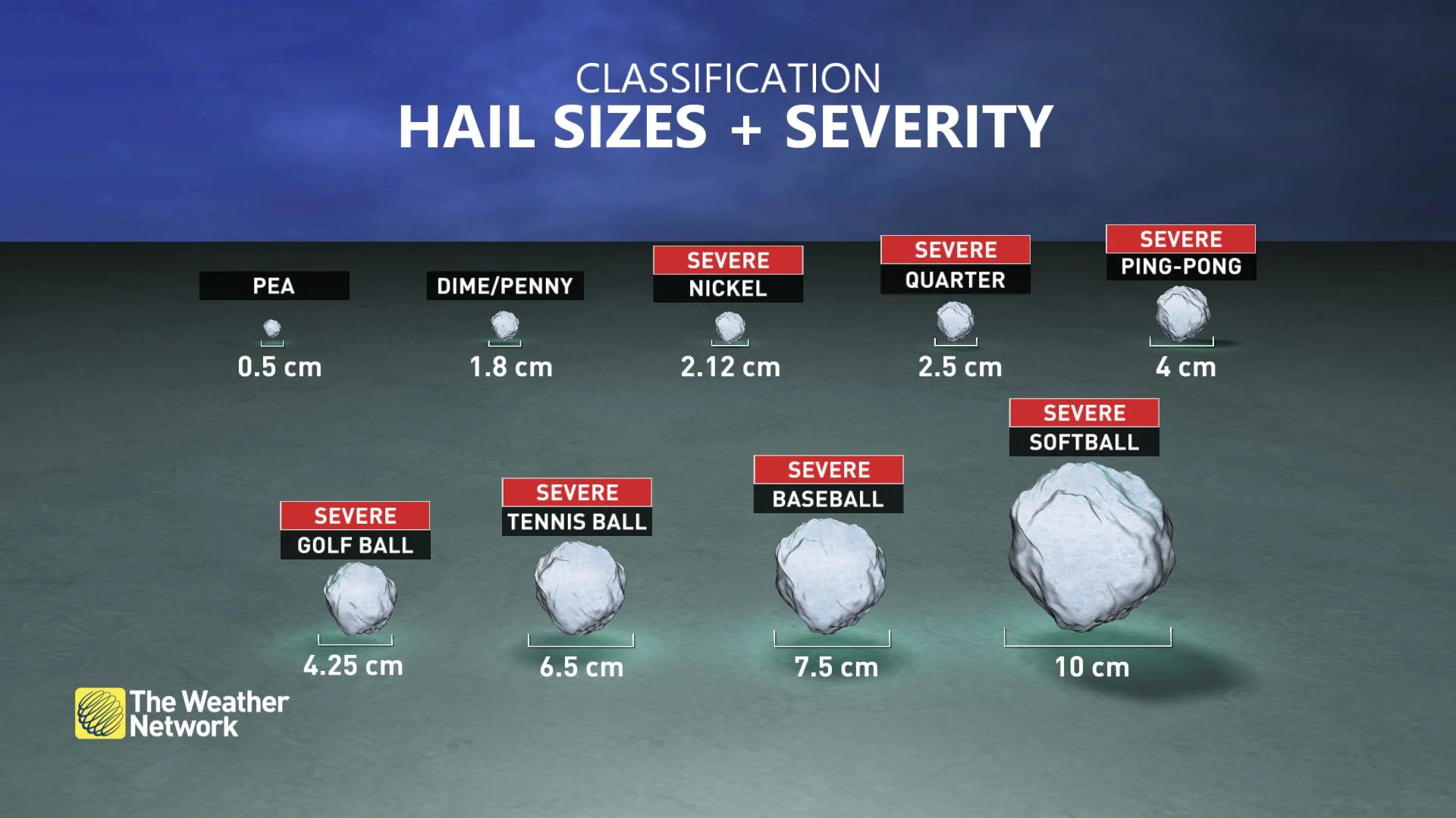
Depending on the severity of the thunderstorm, and thus the strength of the updrafts in the cloud, hail can be smaller or larger. Normally, hailstones vary between the size of a pea and a marble, but vigorous thunderstorms can produce hailstones the size of a golf or tennis ball.
A common comparison with very large hail is the one made to a baseball. Baseball-sized hail can cause serious injuries to humans and animals. It is also responsible for destroying crops, making holes in roofs, walls, windows and windshields, as well as denting vehicles.
The largest hailstone reported in the U.S. was recovered in the town of Vivian, South Dakota on June 23rd 2010. The beast had a diameter of 8 inches, a circumference of 18.62 inches and weighed 1lb and 15 oz. Mr. Lee Scott, who collected it, originally planned to make daiquiris out of the hailstone but fortunately thought better and placed it in a freezer before turning it over to the National Weather Service for certification.
The largest hailstone by circumference was recovered in Aurora, Nebraska, on June 22, 2003. It measured 7 inches in diameter, but 18.75 inches in circumference.
Canada's largest hailstone was that collected at Cedoux, Saskatchewan on August 27, 1973. It measured 114 mm in diameter (4.5 inches) and weighed 290 grams (10.2 ounces).
Other countries of the world where hailstorms are frequent are India, China, Russia and Italy.
WHERE IS HAIL ALLEY?
Thunderstorms in North America are frequent across a considerable number of states, but the highest storm frequency does not necessarily match the highest hail occurrence. While Florida gets the most thunderstorms, Colorado, Wyoming, Kansas and Nebraska usually have the highest frequency of hailstorms. This corridor from the Rockies east into the central Plains is referred by some as "Hail Alley" and it averages seven to nine hail days a year. Other states like South Dakota, Oklahoma, Texas, Missouri, Georgia or the Carolinas, also experience a high average number of hailstorm days.
So why the High Plains and not Florida? It has a lot to do with the freezing level within these huge thunderstorms. In the High Plains the height of the 0°C mark (freezing level or 32°F) is usually closer to the ground than in Florida near sea level.
This means that in Florida, hailstones have much more distance to travel and thus melt, once they get passed the freezing level and before reaching the ground. On the other hand, hailstones within thunderstorms in the High Plains will melt less because the freezing level is closer to the ground. So storm frequency and intensity does help increase hail occurrence, but the key factor to it reaching the ground is also height dependent.
It may come as no surprise that Canada's "Hail Alley" is in Alberta.
The greatest frequency of hailstorms in the country occurs between Calgary and Red Deer. What's so special about this area?
There are three main reasons:
Alberta's croplands provide a source of moist air, which is fuel for thunderstorms.
When this moist air heads toward the Rocky Mountains, it is forced upwards which can trigger the development of storms.
Finally, the higher elevations of east of the mountains mean the freezing level is closer to the ground than in other areas, allowing the hail to make it to the ground before melting in the air.
Since these conditions come together so frequently in this part of Canada in the summer, hailstorms are common. You can learn more about Canada's "Hail Alley" in the video below.
ARE HAILSTORMS BECOMING MORE FREQUENT?
The tendency of our climate in the 21st century is for severe weather events to become even more extreme. Based on this general assumption, a recent study conducted by Cloud Physics Scientists Vittorio Gensini (Northern Illinois University) and John Allen (Central Michigan University) shows how changes in wind patterns across the Earth have been demonstrated to impact the likelihood of weather patterns conducive to severe weather.
The results of this research project show how the jet stream wind patterns with a wavy (meridional) configuration are more likely to produce severe hailstorms. In addition, they have come up with a method that may be useful for the advanced prediction (three weeks) of damaging hailstorms that will very likely have an impact on human life.
With files from Kyle Brittain. Header image courtesy of Kyle Brittain.


