Active Alerts Coquitlam 2, BC
Very windy conditions are expected.
When: Tuesday to Wednesday morning with peak wind speeds expected Tuesday night.
Where: Lower Mainland, Whistler, inland sections of the north and central coast, and Haida Gwaii.
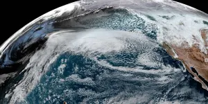
Remarks: A significant fall storm is set to impact the B.C. Coast beginning on Tuesday. A rapidly deepening low pressure system will arrive approximately 400 kms west of Vancouver Island by late Tuesday. This low is forecast to then curl northwards on Wednesday towards the Central Coast, remaining offshore through the period.
Coastal areas will see southeasterly winds increase through the afternoon on Tuesday, with peak wind speeds expected for most areas on Tuesday night. Strong winds are likely to continue on Wednesday morning but should ease later in the day.
Very strong outflow winds can also be expected through mainland inlets and valleys.
Some areas can also expect heavy rain at times during this event, but winds will remain the primary concern.
-Strong winds may down trees or cause tree limbs to break.
-Be prepared for power outages.
-Travel delays will be possible.
-Secure loose outdoor objects.
For emergency preparedness tips visit Safety Canada at: https://www.getprepared.gc.ca/index-en.aspx
###
Please continue to monitor alerts and forecasts issued by Environment Canada. To report severe weather, send an email to BCstorm@ec.gc.ca or tweet reports using #BCStorm.


