Active Alerts Mansfield, PA

Tornado Watch
Issued at Sat 1:12 PM Jun. 29
Issued by: National Weather Service
Description
THE NATIONAL WEATHER SERVICE HAS ISSUED TORNADO WATCH 482 INEFFECT UNTIL 8 PM EDT THIS EVENING FOR THE FOLLOWING AREASIN PENNSYLVANIA THIS WATCH INCLUDES 26 COUNTIESIN CENTRAL PENNSYLVANIABEDFORD BLAIR CAMBRIACAMERON CENTRE CLEARFIELDCLINTON COLUMBIA ELKFRANKLIN FULTON HUNTINGDONJUNIATA LYCOMING MCKEANMIFFLIN MONTOUR NORTHUMBERLANDPERRY POTTER SNYDERSOMERSET SULLIVAN TIOGAUNION WARRENTHIS INCLUDES THE CITIES OF ALTOONA, BEDFORD, BERWICK,BLOOMSBURG, BRADFORD, CHAMBERSBURG, CLEARFIELD, COUDERSPORT,DANVILLE, DUBOIS, EMPORIUM, HUNTINGDON, JOHNSTOWN, LAPORTE,LEWISBURG, LEWISTOWN, LOCK HAVEN, MANSFIELD, MCCONNELLSBURG,MIFFLINTOWN, MOUNT UNION, NEWPORT, RENOVO, RIDGWAY, SELINSGROVE,SHAMOKIN, SOMERSET, ST. MARYS, STATE COLLEGE, SUNBURY, WARREN,WAYNESBORO, WELLSBORO, AND WILLIAMSPORT.
Full details  
Flood Watch
Issued at Sat 12:50 PM Jun. 29
Issued by: National Weather Service
Recommended Action

You should monitor later forecasts and be alert for possible FloodWarnings. Those living in areas prone to flooding should be preparedto take action should flooding develop.

Description

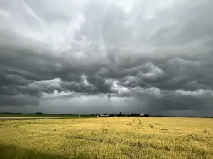
* WHAT...Flooding caused by excessive rainfall continues to bepossible.* WHERE...The northern and central mountains of Pennsylvania.* WHEN...Through late tonight.* IMPACTS...Creeks and streams may rise out of their banks. Floodingmay occur in poor drainage and urban areas.* ADDITIONAL DETAILS...- Several rounds of rain and occasional thunderstorms willoccur into the first part of the night. Rainfall amounts ofover 2 inches per hour are possible where thunderstorms trainover the same location. This will lead to the threat oflocalized flash flooding, especially in poor drainage andlow-lying areas in cities and towns, and along roads adjacentto small streams and creeks.- http://www.weather.gov/safety/flood