Blazing Arctic temperatures continue to feed fires in Canada's north
Blazing hot temperatures and dry conditions in Canada's High North will continue into the start of the week.
The first week of August was historic for Canada's northern territories in that a prolonged heat wave has been breaking heat records across several northern communities.
A hot and dry pattern over the Northwest Territories will continue to keep temperatures at stifling levels for the second week in a row.
This pattern is all thanks to a ridge of high pressure, which has sat over the region since the beginning of the month and has been ushering in the heat while also ushering out any precipitation.
CANADA'S WILDFIRES: Visit The Weather Network's wildfire hub to keep up with the latest on the active wildfire season across Canada.
Temperatures within the Arctic Circle reached over 36°C last week, shattering August and all-time heat records.

Little Chicago, N.W.T., even recorded higher temperatures last week than Miami and Los Angeles!
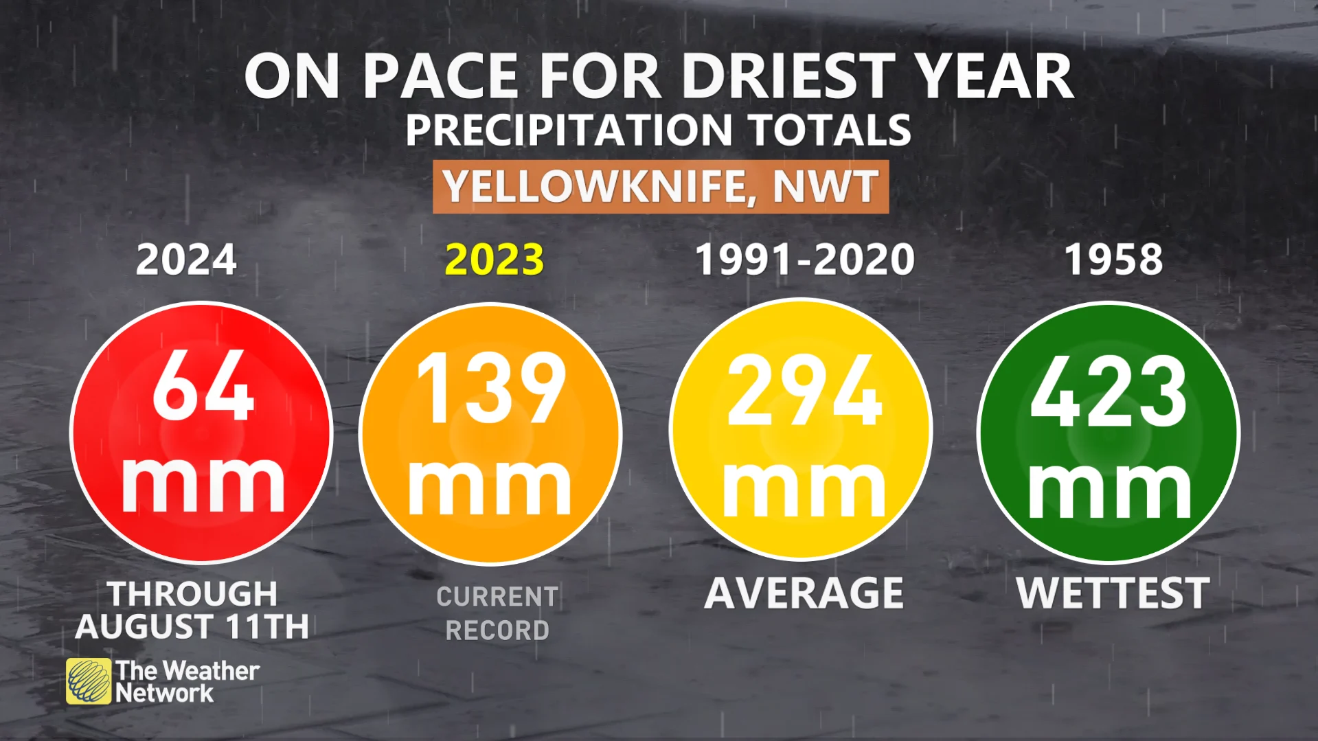
Additionally, Yellowknife, N.W.T., has only seen 64 mm of rain so far this year, putting them on track to see their driest year ever. The previous record for the driest year was only set last year in 2023, when the territory saw just 139 mm of rainfall.
Undoubtedly, this heat and dry pattern has set the stage for volatile wildfire conditions throughout the region. Some areas in the Far North are currently seeing 100,000 hectares of land being scorched per day.
313,539 hectares burned in the territory between Aug. 10-11. To put that into perspective, that is 60 per cent of the entire wildfire season's average burned in one day.

These volatile conditions will now continue through the beginning of the week, but reprieve is on the way.
The high-pressure ridge will begin to break down in the middle of the week, ushering cooler temperatures in the mid-teens—seasonal temperatures for the region at this time of year.
The smoke produced from the blazing fires will linger for longer, however, and be at the mercy of the jet stream.

SEE ALSO: Best practices to keep yourself safe from wildfire smoke
Poor air quality is expected to linger across the region through the week, as well as sink into northwestern Ontario and northern Quebec.
Those in Atlantic Canada won't be spared from the smoke, either. Low-level smoke will result in very poor air quality this week as the jet stream carries the smoke eastward. Some smoke could even reach the north Atlantic and Europe by the end of next week!
Remember to avoid outdoor activities when smoke levels are high, especially for those who are more at risk of respiratory illnesses, such as elders, young children, or those with asthma.
Stay with The Weather Network for more forecast information and updates on your weather across Canada's north.


