Final full day of preparations for Florida residents as Milton bears down
Hurricane Milton stays on a dangerous course towards Florida, with catastrophic and life-threatening impacts possible
Widespread hurricane and storm surge warnings line much of Florida's coastal regions, as Hurricane Milton is forecast to remain an extremely dangerous hurricane through its landfall in the U.S. overnight Wednesday.
"Today is the last full day for Florida residents to get their families and homes ready, and evacuate if told to do so," said the U.S. National Hurricane Center (NHC) in its Tuesday afternoon update.
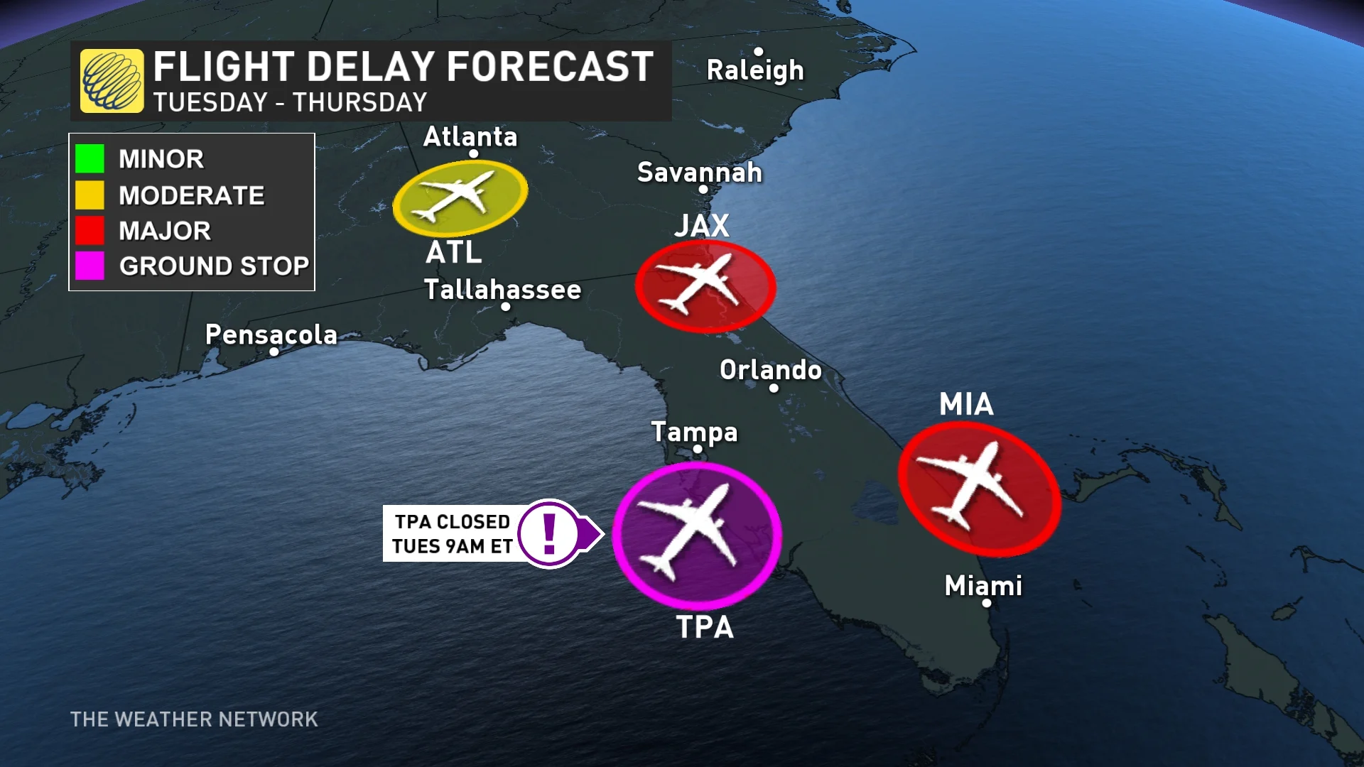
The major hurricane has started to strengthen again to a Category 5 storm on its way to Florida Tuesday. More than a million people were ordered to evacuate from its path ahead of landfall, which the NHC projects will likely hit near the Tampa Bay metropolitan area. In preparation for Milton's arrival, officials have called this the largest evacuation since 2017 when Hurricane Irma hit.

Pinellas County, which includes St. Petersburg, ordered the evacuation of more than 500,000 people, while Lee County said 416,000 people lived in its mandatory evacuation zones. At least six other coastal counties have ordered evacuations, including Hillsborough County, and the city of Tampa. The mass evacuations have resulted in long lines at gas stations and concerns of major traffic jams.
DON'T MISS: Nightmare scenario unfolding for Tampa with Milton's potential hurricane track
Milton rebounds in strength to Category 5
Milton quickly became one of the fastest, intensifying storms on record in the Atlantic Ocean, surging from a tropical depression to a dangerous Category 5 hurricane in just 49 hours.
After briefly being downgraded to a Category 4 hurricane, Milton has rebounded in intensity and now boasts maximum, sustained winds of 270 km/h as of Tuesday evening, as a Category 5 hurricane. On its current trajectory, a turn toward the northeast is expected through Wednesday.
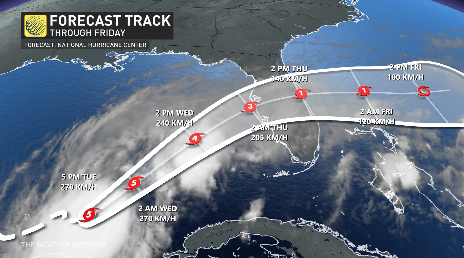
"On the forecast track, the centre of Milton will move across the eastern Gulf of Mexico through Wednesday, make landfall along the west-central coast of Florida Wednesday night, and move off the east coast of Florida over the Atlantic Ocean on Thursday," the NHC says.
Milton is now the strongest storm on our planet for 2024, beating out Hurricane Beryl, which had the previous strongest winds of 270 km/h, as well as typhoons Yagi and Krathon, which both held the record until now for the lowest, barometric pressure at 915 millibars. Hurricane Milton set a new record with maximum, sustained winds of 285 km/h and a barometric pressure of 897 mb.
WATCH: N.S. crews headed to Florida for Hurricane Milton
Widespread warnings line Florida
A storm surge warning is in effect for Florida's west coast from Flamingo northward to the Suwannee River, including Charlotte Harbor and Tampa Bay. It's also in effect for the east coast of Florida, from Port Canaveral northward to the mouth of the St. Mary's River, including the St. Johns River.
The hurricane warning has been issued from Bonita Beach northward to the mouth of the Suwannee River, including Tampa Bay, as well as from the Indian River-St. Lucie County Line northward to Ponte Vedra Beach.
Widespread flash flooding is anticipated before and during the storm, with destructive winds, a life-threatening storm surge, and the risk for tornadoes as the storm hits the region. Power outages are expected to last for days in the storm's wake.
Florida, and much of the Deep South are still recovering from the widespread devastation and destruction caused by Hurricane Helene, which killed more than 200 people across six states late last month.
The Tampa Bay branch of the U.S. National Weather Service said on X that if Milton stays on its current track, it will be the worst storm to impact the Tampa area in more than 100 years.
Wednesday overnight landfall likely
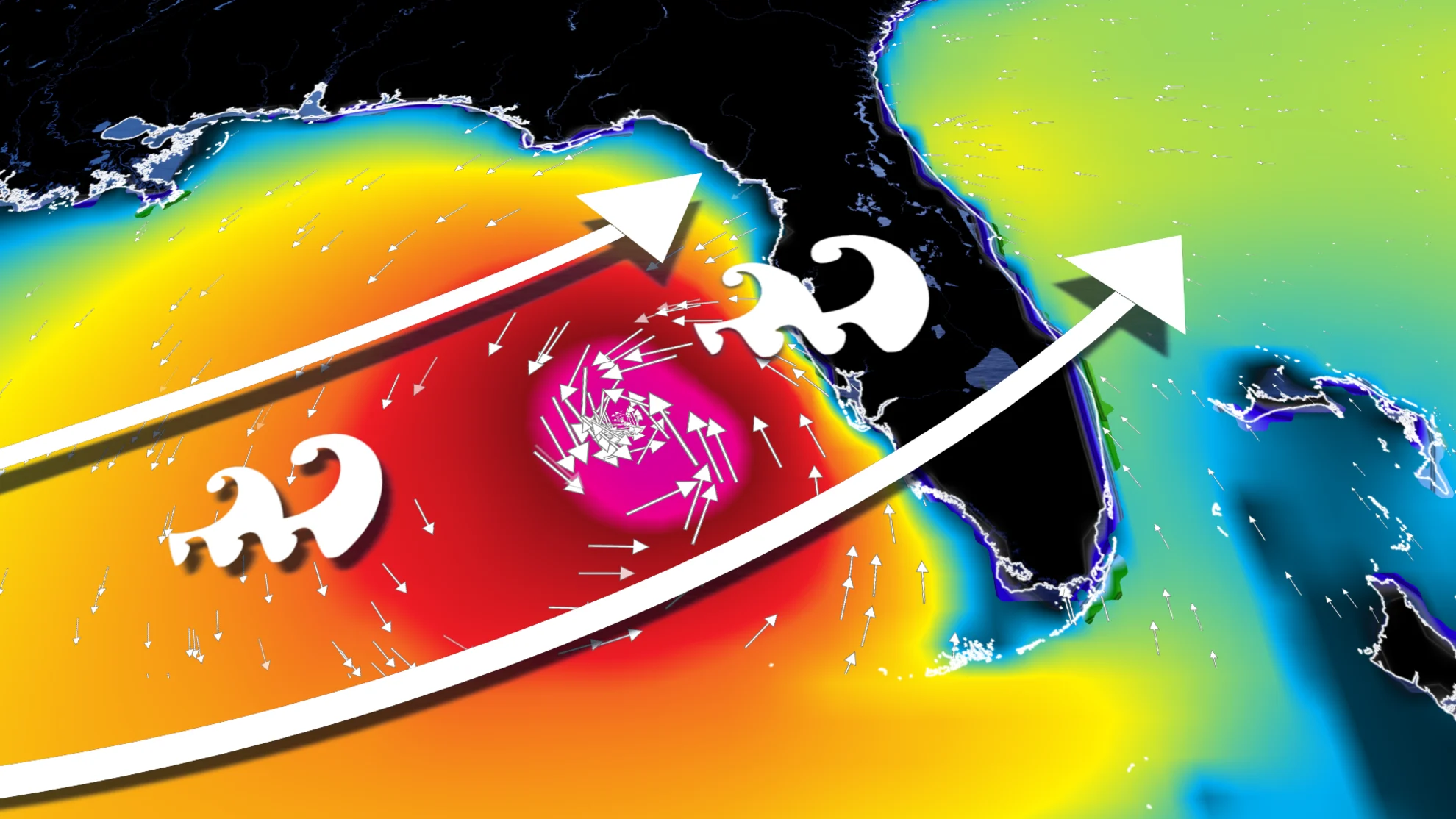
Favourable environmental conditions, along with very warm ocean waters, have allowed the system to continue intensifying as it heads east toward Florida.
A landfall along Florida's west coast is likely Wednesday night through the overnight period. The precise landfall location is still somewhat uncertain. Milton's powerful core could move ashore anywhere from Fort Myers in the south to the hard-hit Big Bend region to the north. Landfall could end up somewhere near Tampa Bay, Sarasota, or Cape Coral.
RELATED: Why Florida’s west coast is so vulnerable to storm surge flooding
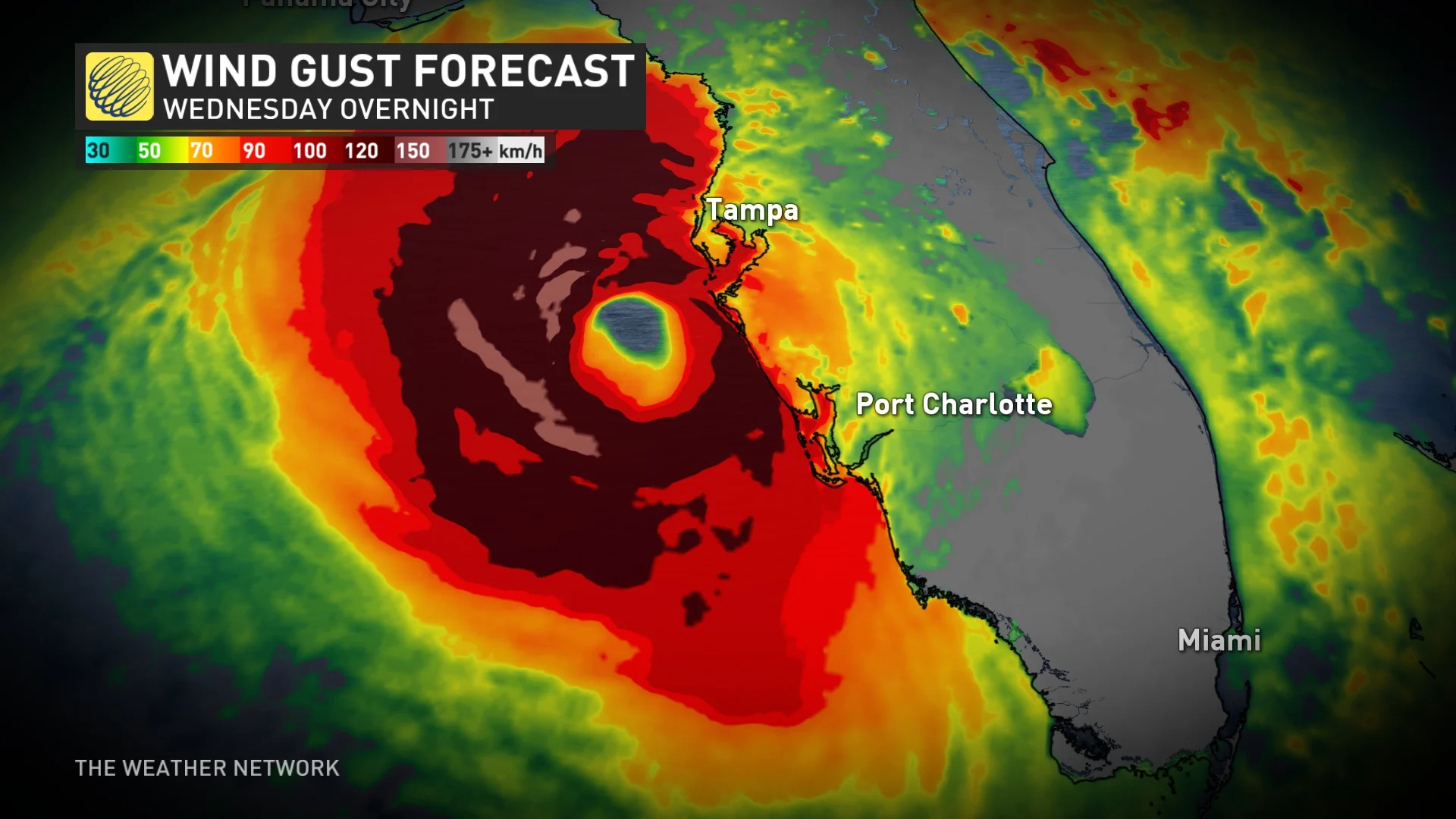
It's worth noting that the storm's strength and fast-forward speed would bring strong winds well inland across Florida. Depending on the ultimate track, this could bring dangerous winds into the Orlando metro area and portions of Florida’s east coast, as well.
Life-threatening flash flooding and storm surge
Most of the Florida Peninsula is in line for several days of very heavy rainfall that'll culminate in the hurricane’s arrival on Wednesday. A surge of tropical moisture will collide with a stationary front parked over Florida. This front will help wring out the excess moisture in the atmosphere, leading to a long period of heavy rains before Milton's landfall.
Many communities throughout Florida could see 125-300+ mm of rain during this event. Some localized areas could even see up to 450 mm.
"This rainfall brings the risk of life-threatening flash and urban flooding, along with moderate to major river flooding," the NHC warns.
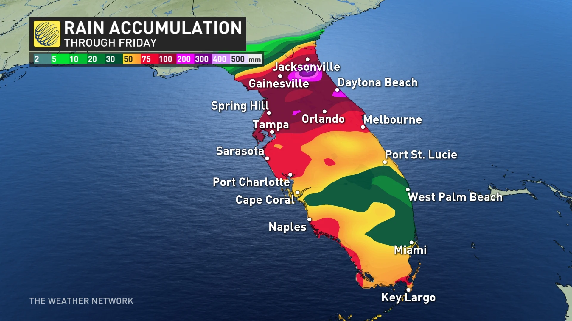
Milton will also produce rainfall totals of 50-100 mm across the Florida Keys through Thursday.
MUST SEE: Why focusing on a hurricane’s category is downright dangerous
Powerful winds in the core of the hurricane will cause significant damage near the point of landfall. Damage to homes and businesses is likely, along with long-lasting power outages in the hardest-hit communities.

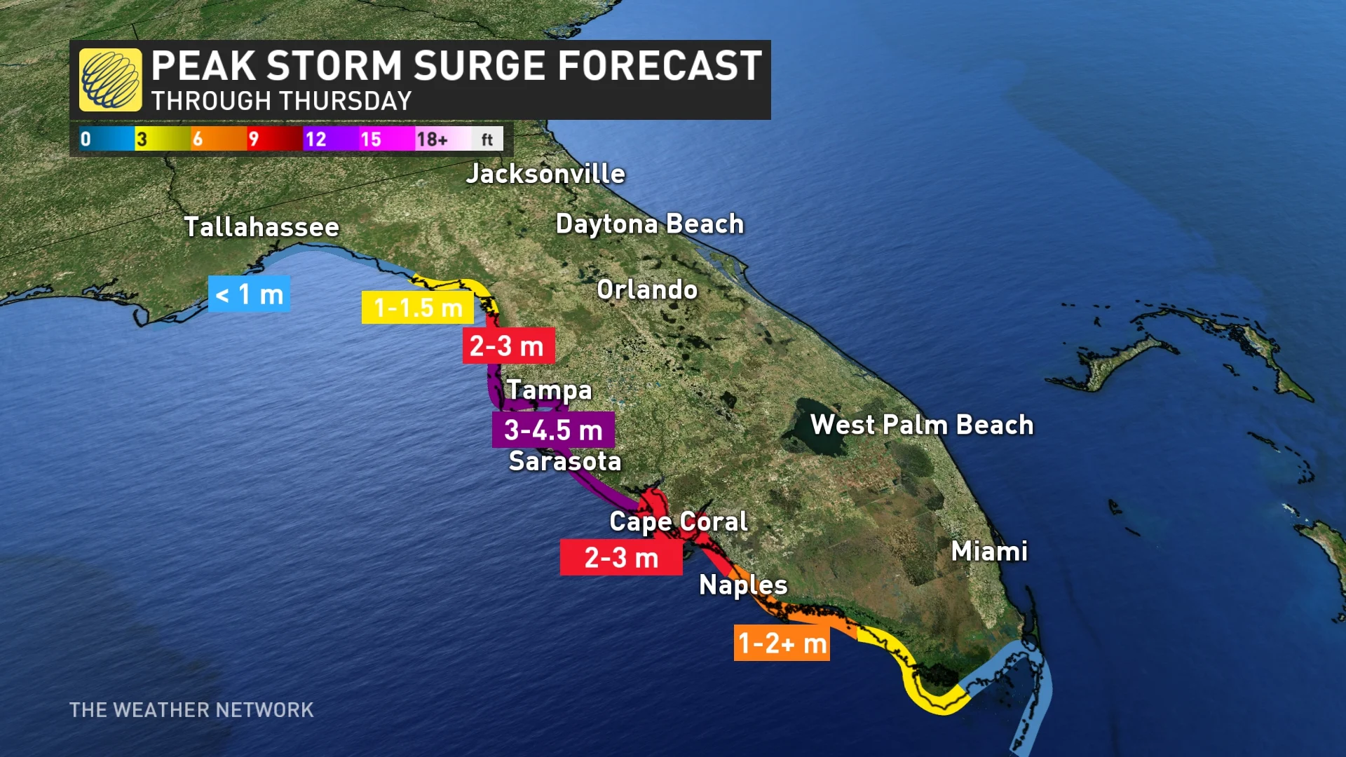
A life-threatening storm surge is likely where the hurricane makes landfall. Florida’s western coast is exceptionally vulnerable to storm surge flooding. Depending on the hurricane’s ultimate track, this could be a very dangerous situation for the Tampa Bay area.
"The combination of a dangerous storm surge and the tide will cause normally dry areas near the coast to be flooded by rising waters moving inland from the shoreline," NHC warns.
In Tampa Bay, water heights could reach 3-4.5 metres above ground. The deepest water will occur along the immediate coast near and to the south of the landfall location, where the surge will be accompanied by large and dangerous waves.
Florida Gov. Ron DeSantis is warning of a potentially higher storm surge and more power outages from Milton compared to Helene, with damage from Helene likely to be compounded.
"There are some areas with a lot of debris that is there, so if you get hit with a major hurricane, what's going to happen to that debris? It's going to increase the damage dramatically," DeSantis said in a news report from Reuters. "This is all hands on deck to get that debris where it needs to be."
As with any landfalling tropical system, tornadoes will also pose a threat to the Florida Peninsula as Milton makes landfall this week. Stay alert for tornado watches and warnings throughout the state. Tropical tornadoes can happen quickly with reduced tornado warning lead time.
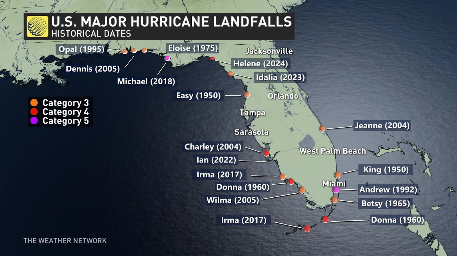
A major hurricane hasn't directly hit the Tampa Bay area in living memory. The last major hurricane to strike the region occurred back in 1921.
WATCH: Florida couple evacuates home ahead of Hurricane Milton
With files from Reuters


