Intense heat moves east on the Prairies as rain helps fire stricken Alberta
Severe thunderstorm risk to hit Alberta as heat finally decreases in the province
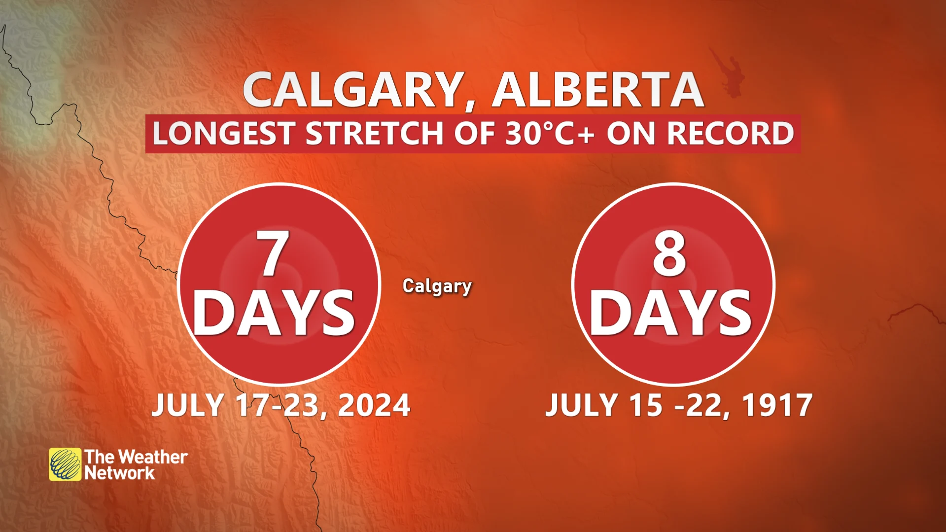
For the first time in more than a week, the temperature failed to reach 30°C in downtown Edmonton on Tuesday, so the record-streak comes to an end. However, Calgary could tie its streak on Wednesday, with a record that’s stood for over a century. The forecast high on Wednesday is 33°C.
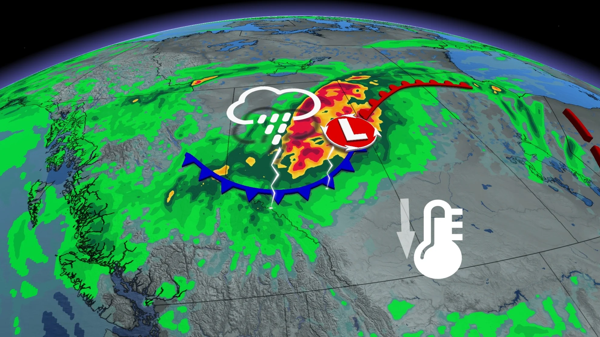
The heat is slowly fading as the ridge relaxes and tracks eastward, making way for an upper trough that will bring the risk for thunderstorms, rain, and cooler temperatures through the second half of this week.
On Wednesday, there is a risk of thunderstorms as a low pressure system slowly tracks northward across Alberta through Thursday. An upper low pushing in from the Pacific will provide upper level support for thunderstorm development.
Ample moisture pulling northward with the low will bring widespread rain Thursday and Friday in Alberta, with embedded thunderstorms likely Wednesday and Thursday across both Alberta and Saskatchewan.

Wednesday's risk in Alberta has to potential for damaging winds and large hail. Hail size could approach 4 cm in the largest storms northeast of Edmonton.
Nocturnal thunderstorm are also expected Wednesday overnight, developing near the northern foothills and Elbow region, and tracking northeastward, and near Edmonton. These storms could bring heavy downpours through the night.
RELATED: Thousands of tourists among those forced to flee Jasper National Park
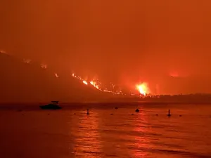
Massive wildfires are burning south of Jasper, forcing the evacuation of thousands from the national park on Monday night. The flames were moving closer to the community as of Tuesday evening, and relief can't come soon enough.

By Wednesday overnight, widespread rain will begin to overspread northern Alberta, including the Jasper area.
Thursday through Friday, a widespread 20-40 mm of rain is forecast across northern Alberta, with up to 75 mm possible north of Edmonton.
As of Wednesday morning, 175 active wildfires burn across Alberta, with most reported through the north.

The Air Quality Health Index is expected (AQHI) to improve somewhat for northern areas, but deteriorate across the south. Both Calgary and Airdrie have an AQHI forecast of 10+ on Wednesday.
DON'T MISS: Staying hydrated on a hot day is a lot more important than you think
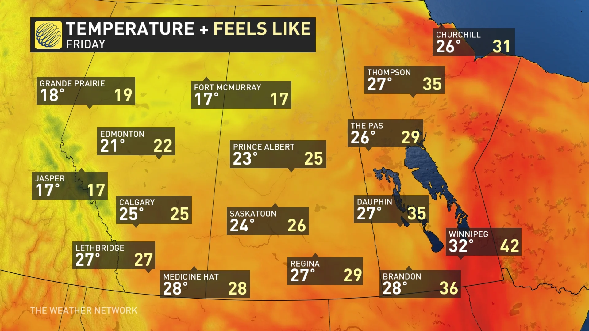
Meanwhile, extreme heat is building across Saskatchewan and Manitoba where temperatures will push into the mid-to-upper 30s over the next couple of days, with very mild overnight lows only dipping down to the 20s.
Heat warnings are in place for southern Saskatchewan. If you need to be outside, wear appropriate sunscreen, a wide-brimmed hat, sunglasses and light, loose-fitting cotton clothes.
Severe weather safety
Tornadoes are a threat to many parts of Canada during the spring and summer months, and even if the environment is extremely favourable for supercell tornadoes, forecasters have limited ability to say when or if a specific storm will produce a tornado.
DON'T MISS: Watch? Warning? How we communicate severe weather in Canada
To help keep you and your family safe, below is a refresher on what's most important to remember when a tornado warning is issued in your area.

TOP TIPS COURTESY OF RED CROSS:
Identify a safe place in your home where household members and pets will gather during a tornado: a basement, storm cellar or an interior room on the lowest floor with no windows.
In a high-rise building, pick a hallway in the center of the building. You may not have enough time to go to the lowest floor.
In a mobile home, choose a safe place in a nearby sturdy building. If your mobile home park has a designated shelter, make it your safe place. No mobile home, however it is configured, is safe in a tornado.
Additional tip: You'll also want to make sure you are wearing good shoes. If your area takes a direct hit, you do not want to walk through a debris field barefoot.
WATCH: An in-depth analysis of the Jasper fire situation unfolding
Widespread humidex values spilling into the low 40s are likely across central and southern Saskatchewan, and Manitoba over the next couple of days.
Some guidance suggests it’s possible to hit 25°C dew points across eastern Saskatchewan and portions of Manitoba, making things feel like the mid-40s in some locations.
SEE ALSO: Best practices to keep yourself safe from wildfire smoke
Temperatures will finally drop as a stalling low in northern Alberta and Saskatchewan ushers in a cooler, northwesterly flow, sending daytime highs down to the upper 20s for Saskatchewan. But, they will remain stubbornly sticky across Manitoba into this upcoming weekend.
Stay with The Weather Network for all the latest on conditions across Alberta.