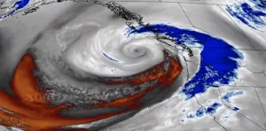
Power, travel disruptions possible in B.C. with next entry in storm parade
Multiple rainy and snowy systems will march into B.C. this week, also bringing blustery wind gusts that are likely to cause power outages and interrupt travel.
British Columbia will once again be bracing for numerous impacts this week as an active pattern unfolds.
While that means good news for ski resorts, it will be troublesome for folks at lower elevations. With several systems expected to bring rain and alpine snow, along with intense wind gusts, folks can expect travel and power disruptions this week.
DON’T MISS: What does a ‘missing’ La Niña mean for Canada’s winter?
Impact to travel is likely in areas that see alpine snow, blustery winds and the heaviest rain, with localized flooding and water pooling on roads a major threat. Residents are urged to clear storm drains of leaves and debris amid the ongoing miserable weather.

High winds may also cause tree branches to break, leading to disruptions and power outages through the mid-week mark.
Storm parade stays locked over B.C. this week
The third of this atmospheric trio will feature a stronger low developing Tuesday evening in the eastern Pacific. Wind warnings will likely be issued with this low-pressure system.
The main impact from the system is the strong wind gusts as the warm front moves ashore bringing in strong, southerly winds.

MUST SEE: How the Sun Belt saw snow before most major Canadian cities
Wind gusts of 70-90+ km/h are possible for the Juan de Fuca, Strait of Georgia and Greater Victoria regions. Western Vancouver Island could see similar ranges, with wind gusts of 70-90 km/h.
Gusts between 50-60 km/h are forecast in Metro Vancouver, and up to 80 km/h for Delta, as well as in the exposed areas along the shoreline in the south and west.

As a result of the gusty winds and heavy rain, people can expect power outages, ferry delays and localized flooding.
It’s unlikely we’ll see more than 100,000 outages as compared to last Monday, but expect tens of thousands of customers to lose power.

Late ferry sailings on Tuesday are in jeopardy of cancellation. Check BC Ferries ahead of time.
The biggest snow of the fall season is expected in the Coquihalla and Allison passes across southwestern B.C, where close to 30 cm of snowfall is possible through Wednesday morning, but temperatures will be hovering near freezing so pass summits will get the most.

Long range shows freezing levels more typical of December, and highs in the mid-to-single digits, even reaching down to sea level by early next week.
Mountain pass travellers can expect tricky commutes late Tuesday into Wednesday, especially through the Interior where colder pockets of air will remain.
Be sure to check back for the latest forecast updates across B.C.


