
Oscar remnants arrive in Atlantic Canada, raising outage and flooding risk
Rainfall warnings remain in effect across parts of eastern Nova Scotia and Newfoundland as leftovers from Oscar threaten heavy downpours and localized flooding this weekend
The remnants from what was once Hurricane Oscar have arrived in Atlantic Canada, bringing soaking rains and strong winds to parts of the region through Saturday. While Oscar's impacts won't be as severe as the flooding rains and mudslides felt across Cuba and the Bahamas earlier this week, the moisture-packed system has has prompted rainfall warnings across Newfoundland and parts of eastern Nova Scotia.
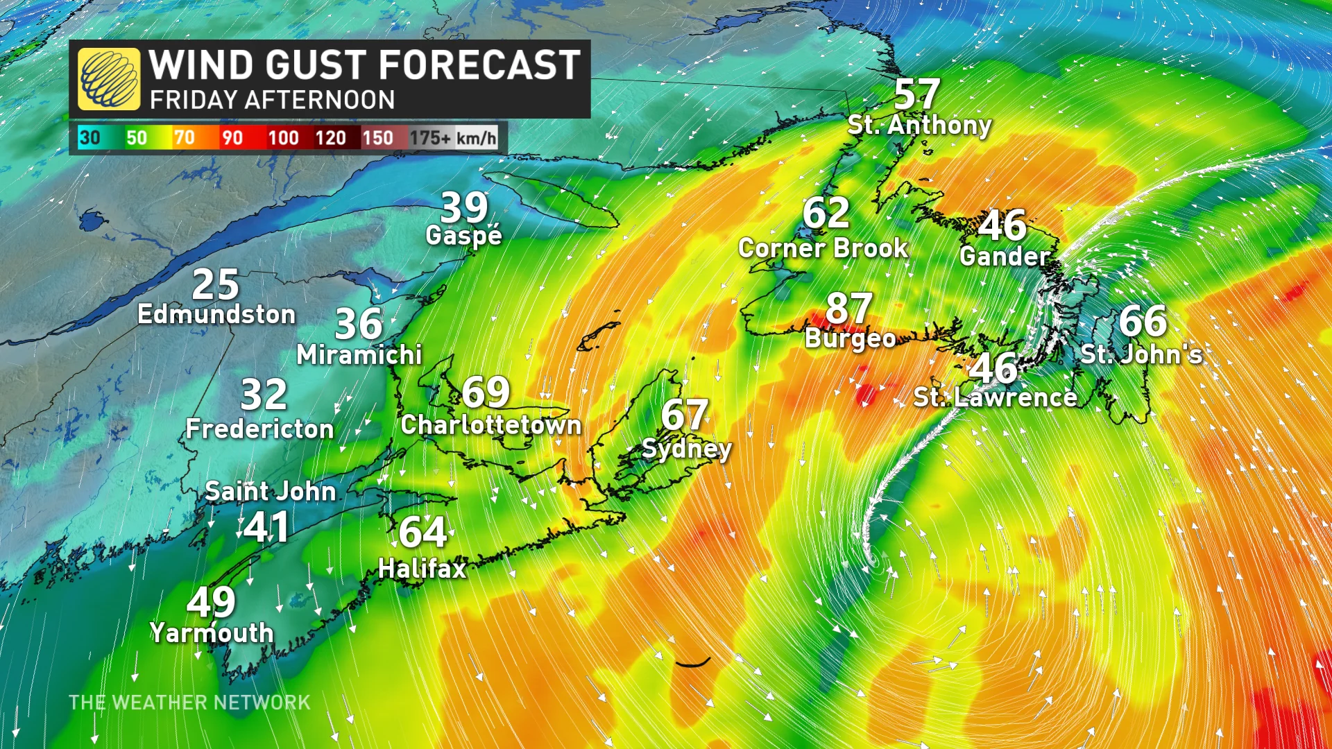
Very heavy rain, a risk for localized flooding, and windy conditions are the main threats into Saturday, with sections of central and eastern Newfoundland bearing the brunt of this tropical impact. In some of the harder-hit areas, as much as 100 mm of rain could fall, with the heaviest of the rain falling throughout the day on Friday. At times, intense rainfall rates of 20 mm per hour could occur.
Visit The Weather Network's hurricane hub to keep up with the latest on tropical developments in Canada and around the world
Water levels in creeks and streams will likely be elevated, so residents are urged to keep an eye on the warnings, and avoid any areas at risk of overflowing.
"Heavy downpours can cause flash floods and water pooling on roads," says Environment and Climate Change Canada (ECCC) in the warning. "Don't approach washouts near rivers, creeks and culverts."
Scattered power outages are possible as well, as winds continue into Saturday.
Localized flooding with heavy downpours into Saturday
The potent cold front that's been tracking across the country this week, and significantly cooling temperatures in its wake, moved into the Maritimes on Thursday, helping to draw the remnants of Oscar into Atlantic Canada.
The rainfall started on Thursday but increased in intensity on Friday, mainly over Newfoundland. Rainfall warnings cover much of central and eastern Newfoundland, as well as Sydney Metro and Cape Breton County.
A general 40-60 mm is forecast across eastern Nova Scotia, while total rainfall amounts of 75-125 mm are possible in some of the hardest-hit regions of central and eastern Newfoundland. During the heaviest downpours, rainfall rates could reach as high as 20 mm per hour.

Hazardous driving conditions from water pooling on roadways is likely, with the risk for road shoulder erosion and washouts, as well.
So far, St. John's airport has recorded around 100 mm this month, a similar amount forecast with this system through Saturday morning. Friday may actually end up as the wettest day of the year so far for St. John’s, beating out the previous 53.6 mm of rain that fell on March 8.
Meanwhile in Gander, the wettest day of the year so far was on February 14 with 38.3 mm of precipitation, all of which fell as snow. Friday was forecast to be the wettest day of the year for the region, with the chance of seeing above 40 mm of rain--more rain than what's fallen in all of October so far.
DON'T MISS: Autumn can still produce intense hurricanes across the Atlantic
Risk of outages as winds pick up
Gusts between 60-90 km/h are expected with this system, with sections of eastern Nova Scotia also in line for the gusty conditions. These winds could result in localized power outages.
Both the rain and winds are expected to gradually ease throughout the day on Saturday. However, the northwesterly winds will drive Arctic air into the Maritimes and across the gulf, which could generate some sea-effect showers.
Chilly weather is expected for early next week, then turning much warmer again by the middle of and late week. In fact, some parts of the Maritimes may see record warm temperatures for Halloween, possibly reaching the lower 20s by Thursday.
A relatively quiet pattern is expected as we head into the first few days of November, but the pattern should become more active as we head into the second week of November.
Be sure to check back for the latest weather updates across Atlantic Canada.