Streams of tropical moisture set to wash over B.C. this week
A stout atmospheric river aiming for B.C. will bring hefty rainfall totals for some areas in the days ahead
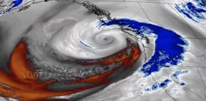
A slug of heavy, tropical-infused rain is on the way to parts of B.C. this week as dual streams of enhanced moisture streaming across the Pacific arrive on the West Coast.
The moisture will arrive courtesy of a decaying typhoon in the western Pacific Ocean, alongside southerly flow moving in straight from Hawaii.
DON'T MISS: A ‘historically strong’ El Niño is possible heading into winter
Rainfall totals of 300+ mm are possible in some areas by the middle of the week.
Visit our Complete Guide to Fall 2023 for an in-depth look at the Fall Forecast, tips to plan for it and much more!
Sunday-Monday rain
A low-pressure system arriving in B.C. on Sunday will push widespread rain across Vancouver Island and the South Coast heading into the day Monday.

Rainfall totals from this weekend’s combined systems will amount to 40-50 mm for downtown Vancouver north of the Fraser River.
RELATED: How a super typhoon will alter Canada's late-October weather
The bulk of the rain will target Tofino, where we could see 100 mm of rain through Monday, while the rain shadow effect brings much lower totals to the Interior valleys.
Looking ahead to this week’s storm potential
B.C.’s atmospheric fortunes this week are a testament to the interconnected nature of our vast global system.
Typhoon Bolaven, once a mighty storm with winds equivalent to a Category 5 storm, entered the final stage of its life this weekend as it rapidly fell apart and absorbed into the jet stream.

The former typhoon’s remnant moisture will stream toward Canada’s West Coast this week, joining forces with another slug of tropical moisture that originated down in Hawaii.
SEE ALSO: B.C. doubled its old wildfire record. Experts say we can take action now
These two plumes of evaporated paradise will qualify as an atmospheric river judging by the amount of moisture pushing into the region—and quite an impactful one, at that. This could qualify as a Category 4 atmospheric river.

Forecasters have medium confidence that the heaviest rainfall will remain north of the Lower Mainland, affecting western Vancouver Island and the Sunshine and Central coasts.
Models currently suggest that rainfall totals could far exceed 200 mm across the northern half of Vancouver Island by the middle of the week, with totals of 100+ mm likely across much of the South Coast.

Be sure to check back over the next couple of days as the specifics and potential impacts of this dynamic and moisture-laden setup becomes clearer.
Stay tuned to The Weather Network for the latest updates across British Columbia.


