Back-to-back storms threaten snow, freezing rain, and gusty winds. Timing, here
Parts of Atlantic Canada are in for a slog of messy, wintry precipitation thanks to stalling systems south of the region
An extended period of wet and windy weather is likely over Atlantic Canada due to an atmospheric gridlock with a strong blocking pattern over the North Atlantic. This will be followed by a retrograding low, essentially reversing direction, and keeping the stormy conditions moving back westwards.
Brace for a messy combination of rain, snow, freezing rain, and powerful winds as a result of the back-to-back storms, with localized flooding and power outages threatening parts of the region through the week. A temperature roller-coaster could also bring some localized mixed wintry precipitation to higher terrain, with some icy travel and the risk for accumulating snow.
DON'T MISS: What’s the snowiest month in your corner of Canada?
More winds and rain in an extended soggy pattern
A strong, high-pressure system off the coast of Europe is preventing low-pressure systems from tracking through Atlantic Canada this week, and instead will have them lingering over the region for days on end.
The system has been pushing rain into eastern Newfoundland as it stalls out just south of the island. The system is wedged between the high off the coast of Europe and a region of high pressure over Quebec, bringing strong winds to Atlantic Canada.

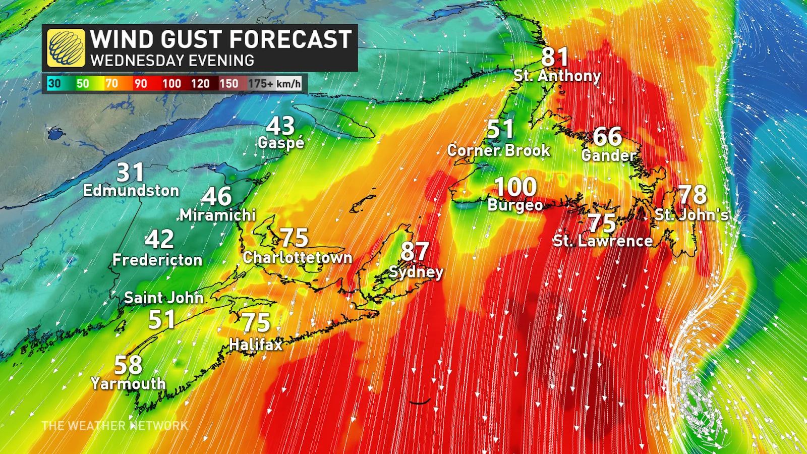
Widespread wind gusts up to 70-90 km/h is expected throughout Atlantic Canada. Some coastal sections in southern Newfoundland could even reach 100 km/h!
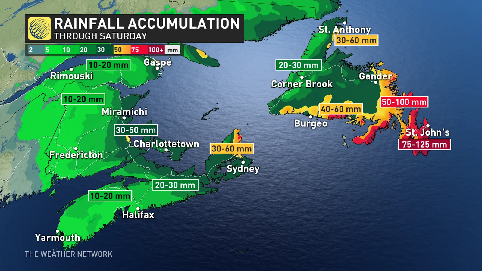
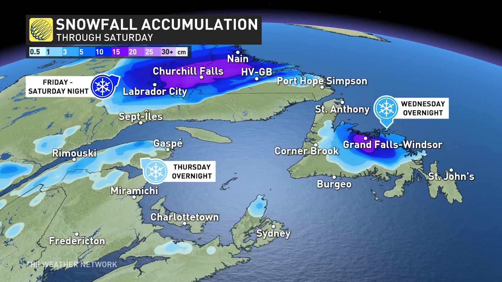
This pattern has set up a boundary over central and eastern Newfoundland, which is bringing persistent heavy rain to the area through Thursday. Current forecast models suggest that 50-100+ mm of rain could fall during this time period, as well as 5-10 cm of snow Wednesday overnight across north and central Newfoundland.

"Localized flooding in low-lying areas is possible," says Environment and Climate Change Canada (ECCC) in the rainfall warning issued for the Avalon. "If visibility is reduced while driving, turn on your lights and maintain a safe following distance."
A widespread snow and freezing rain event is also expected for Labrador, as 5-15 cm is possible for Happy Valley-Goose Bay, Churchill Falls, and Labrador City. Widespread, persistent freezing rain is also likely for southern Labrador.

Be mindful of slippery roadways from the snow and freezing rain while travelling.
Threat for outages
At the same time, winds will also increase drastically over Atlantic Canada, gusting between 70-90 km/h, and even higher along exposed coastlines.
The combination of strong winds and heavy rain could lead to power outages across the harder-hit areas.
SEE ALSO: Rare November twisters touch down in New Brunswick to kick off the month
The low then retrogrades as high pressure forces it back west over top of the Maritimes, bringing more rain to eastern regions to end the week.
Meanwhile, parts of central and western New Brunswick will face some wintry weather, and the potential for slick and icy conditions, as well as accumulating snow. Freezing rain is also possible in northern New Brunswick as milder air moves in over top of the cold air that is presently settled in, making roadways slippery.

This precipitation moves back into the Maritimes on Friday once again, and continues through Saturday before finally tracking north through Quebec.
There is less confidence in how the system will react late week, so it'll be important to stay up-to-date on the forecast and any weather warnings issued in your area.
Stay with The Weather Network for more forecast information and updated on your weather across Atlantic Canada.


