Remains of Beryl to deliver a soaking with flood risk to Ontario, Quebec
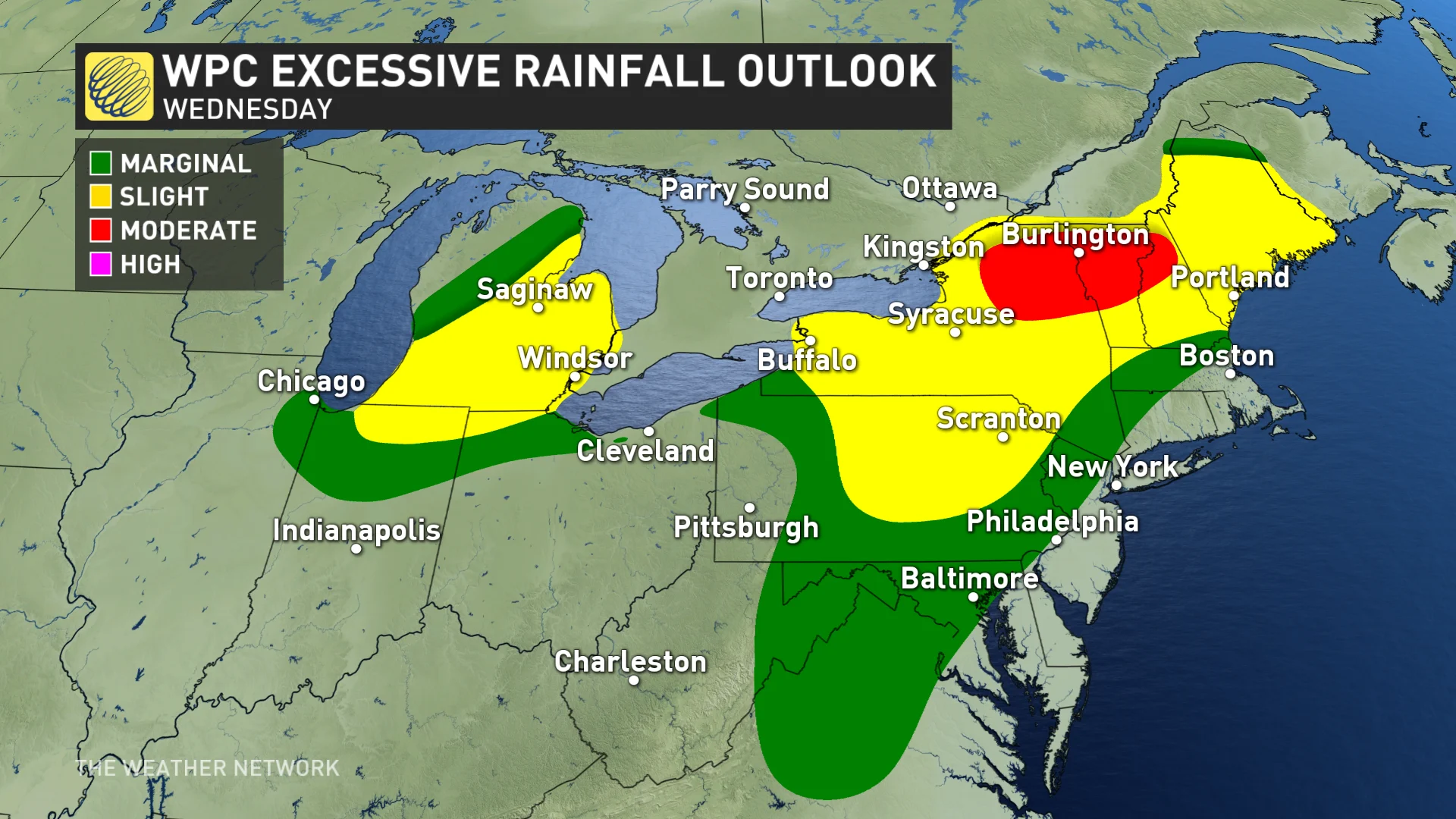
Ontario and Quebec are expected to see a considerable amount of rain as the remnants from what was once Hurricane Beryl track through the region on Wednesday. Some areas could see over 100 mm of rain, increasing the risk of flooding
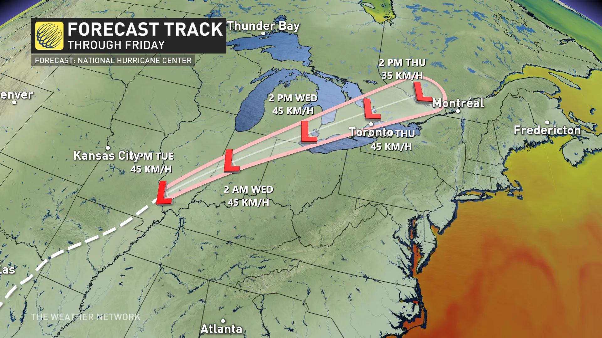
The remnant moisture associated with the once powerful Hurricane Beryl will make its way north of the border this week.
Rainfall warnings and special weather statements cover most of southern Ontario and Quebec, urging residents of the impacts from the incoming onslaught of moisture.
Check out The Weather Network’s hurricane hub for all the latest on storms near Canada and around the world
The rainfall, heavy at times, nudged its way into extreme southwestern Ontario Tuesday overnight before reaching the Greater Toronto Area (GTA) early Wednesday morning. The moisture will arrive in southern Quebec by Wednesday afternoon.
"Heavy downpours can cause flash floods and water pooling on roads. Localized flooding in low-lying areas is possible," says Environment and Climate Change Canada (ECCC) in the rainfall warning.
Residents are urged to stay on top of the weather warnings, including local flood information.
Southern Ontario and Quebec feels Beryl's remnants on Wednesday and Thursday
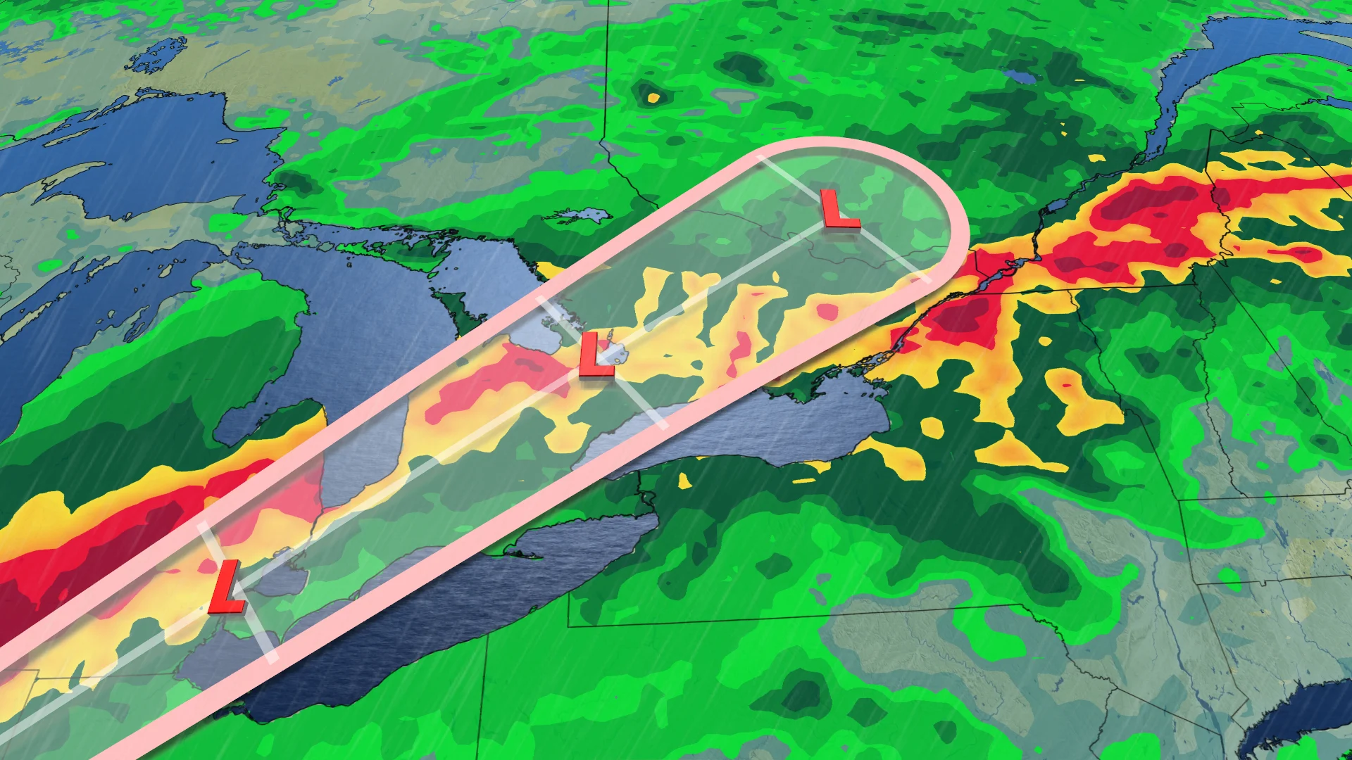
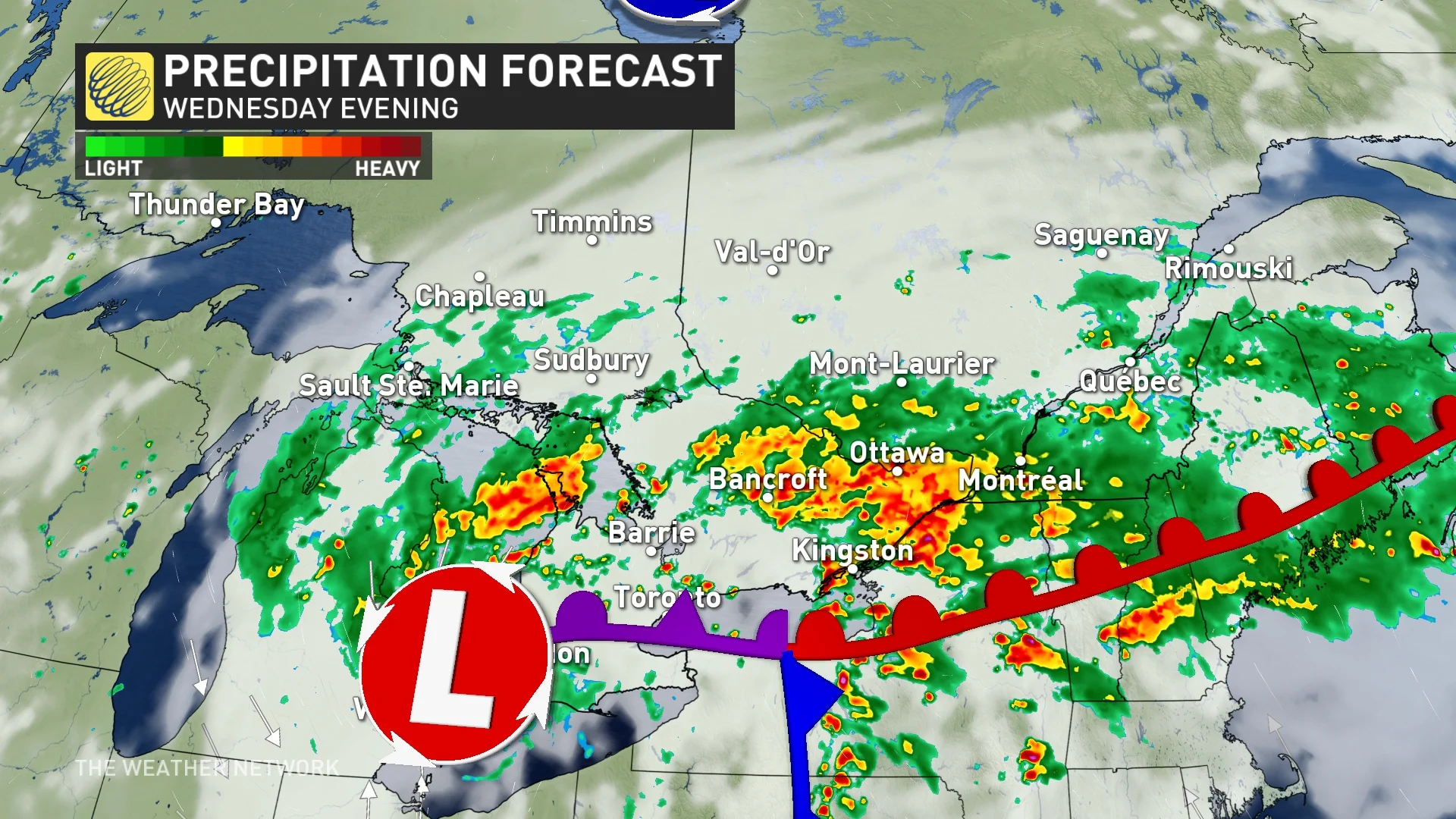
The beginnings of the moisture-packed low came through extreme southwestern Ontario Tuesday overnight, and will ramp up Wednesday morning as it rain pushes east. Eastern Ontario and Quebec can expect to see rainfall by early Wednesday afternoon. It will file in from the south, through the Ohio Valley, over Lake Erie, and move northward in waves through Thursday.
RELATED: Tropical Storm Beryl kills two, knocks out power as it churns across Texas
While driven by an upper-level trough, at the surface, the system will send a warm front through southern Ontario and Quebec. Around this front is where we expect to see the heaviest rain fall, as well as the risk of thunderstorms.
The southwestern and eastern shores of Lake Ontario, as well as the eastern shores of Lake Erie and Niagara region, are at greatest risk of seeing severe storms develop.
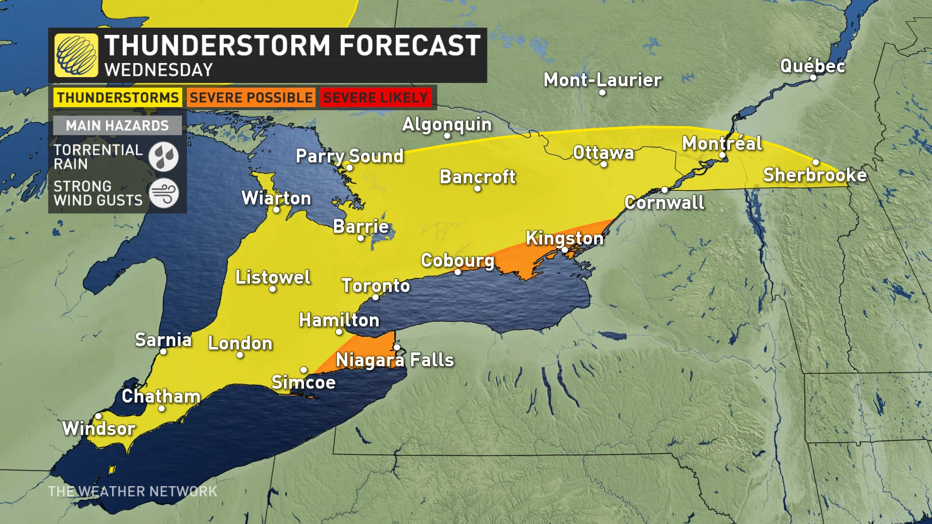
In particular, it is possible that the Niagara region could see some rotating storms in the afternoon.
Between 50-75+ mm of rain is expected across Ontario's Bruce Peninsula, the shores of Lake Huron through to Windsor, and Price Edward County to Cornwall. Across the GTA and through cottage country, and towards Ottawa, between 30-50 mm is expected.
Montreal can expect to see 50-75 mm of rain, with the Eastern Townships picking up between 50-100+ mm.

It will be important to stay alert to all weather warnings in your area, including flood outlooks during the duration of the system.
DON'T MISS: Canadian Red Cross launches appeal to help people impacted by Hurricane Beryl
It can be easy to think that southern Ontario and Quebec is going to be struck by a hurricane-force storm when we say that the remnants of Beryl will reach the provinces. We can assure you, though, that is not the case. Hurricanes need warm oceanic water to sustain themselves and will deteriorate rapidly when starved of that fuel.
By the time this system reaches southern Ontario and Quebec, it won't even be a tropical depression by then.
What we will see is a tropical moisture-laden low-pressure system. The main risks presently with this system in Ontario and Quebec will be heavy downpours, the risk of thunderstorms, and localized flooding.
The localized flooding from heavy downpours could also cause a significant amount of storm water runoff to make its way into Lake Ontario, raising the lake's pollution levels.
This isn't a first for lingering tropical remnants
This isn't the first time Ontario and Quebec has felt the lingering impacts of a tropical system, either.
The hurricane database has 50 cases of remnant storms or tropical depressions moving across southern Ontario since 1876, with only seven of them landfalling in Texas.
Yes, the best track proxy for this setup is Hurricane Ike back in September 2008, a Texas landfalling storm. Of course, Sandy is a prime example of how strong a storm can become once its fully extratropical, occurring in October of 2012.
As well, Hurricane Fran's impacts were felt in southern Ontario in September of 1996 when the then-tropical depression dumped 66.4 mm of rain at Toronto Pearson International Airport.
SEE ALSO: Beware! These dangerous plants are found in Canada
More recently, remnants of Hurricane Isabel dumped more than 30 mm at Pearson airport in September of 2003.
Alberto in May 2018 was also an incredible rarity as the National Hurricane Center kept the storm a tropical depression as it crossed Manitoulin Island on May 31, 2018.
In 2020, Tropical Storm Cristobal made an incredibly rare feat, with tropical remnants crossing Lake Superior on June 10, 2020. The system held onto tropical characteristics into southern Wisconsin.
Stay with The Weather Network for more forecast information and updates on your weather across Ontario and Quebec.


