'It felt like a movie,' says man who saw tornado hit Niagara Region
Four days after moving into his new home in Fort Erie, Ont., Dan Chamberlain feared he may lose it — to a tornado.
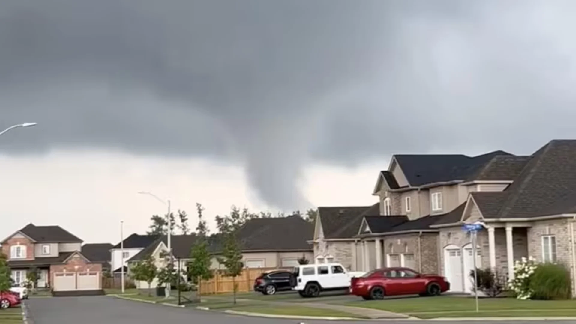
He captured footage of what appears to be a tornado that touched down in Niagara Region and whirled near his home on Monday.
"It felt like a movie … I couldn't even really believe what I was seeing," the 34-year-old told CBC Hamilton.
"My heart started pounding a little bit and I was thinking, 'Oh man, that was such a dangerous position to be in.'
I'm just so lucky I was where I was and it doesn't seem like anyone was severely hurt."
Connell Miller, an engineering researcher with the Northern Tornadoes Project (NTP) at Western University, told CBC Hamilton at least one tornado was in the area that day. No injuries have been reported.
Miller's team works to confirm tornadoes and share their findings with the federal government. Geoff Coulson, a warning preparedness meteorologist with Environment Canada, also said at least one tornado landed, citing NTP.
"It's the videos we saw on social media of a clear funnel touching the ground that confirmed to us a tornado occurred," Miller said.
WATCH: Another view of the possible tornado
Damage in Fort Erie, Port Colborne and Buffalo
NTP has been in the region surveying damage and looking to confirm if more than one tornado visited the pocket in southern Ontario. He noted there was damage reported in Port Colborne, Ont.
Fort Erie Mayor Wayne Redekop told CBC Hamilton it's "disconcerting" to hear some properties, trees and vehicles were damaged. He said there's no budget for disaster relief, but there are some local resources that can be allocated depending on the circumstances.
While NTP has told CBC it is still investigating, Redekop said he received confirmation from NTP that two tornadoes touched down.

At least one tornado hit Niagara Region on Monday, Aug. 5. (Submitted by Dan Chamberlain)
He said one tornado went through Stevensville and went east. Another tornado touched down to the west near Greater Fort Erie Secondary School and move toward Garrison Road before going near the Peace Bridge, according to Redekop.
Chamberlain said he lives right in between those areas and also heard about damage in both areas.
Patricia Martel, manager of Niagara Region's emergency management, noted how employees at a Walmart near Fort Erie saw the tornado and corralled people into safety.
Port Colborne Mayor Bill Steele said at least one property on Brookfield Road was damaged, but thankfully and most importantly, no one was hurt.
"We can fix buildings but a lot of times somebody gets killed by an incident like that. That's the worst case scenario," he said.
Redekop and Steele noted downtown Buffalo was also hit by a tornado Monday but said it's unclear if that's connected to the tornado in Niagara.
Buffalo was struck around 1 p.m., with the tornado starting at the shore near where the lake flows into the Niagara River, according to the National Weather Service. It caused damage to buildings, flipped cars and sent debris swirling over the city's core.
Steele, Redekop and Martel all say Environment Canada didn't issue a warning ahead of the tornado.
WATCH: A video recorded on Monday afternoon shows a funnel cloud and flying debris in downtown Buffalo, New York
Most tornadoes in Canada hit before warning
oulson said Niagara and Buffalo likely experienced landspout tornadoes, caused when winds collide at surface level that triggers a rotation.
"These types of tornadoes don't have a strong signature on radar, they don't really show rotation in the low to mid levels of the atmosphere that the radar can pick up on," he explained.
Environment Canada said Canada has the second highest tornado occurrence rate in the world behind the United States, most often happening in the Prairies and southern Ontario and peaking in late June and July.
But between 2019 and 2021, only 23 per cent of tornadoes were preceded by a warning, a percentage that rose slightly to 35 per cent in 2022, according to NTP.
David Sills, executive director with the tornado project, said Environment Canada has recently improved its tornado alerting program, but he says the agency should be issuing more warnings — even if officials aren't always accurate.
"The public loses trust when they get the warning after the damage has occurred or they don't get any warning at all," Sills said in a recent interview.
"That's when they really lose trust in the system."
Sills says the department should train its forecasters to more quickly assess unpredictable weather patterns and to better use data generated from radar and satellite imagery for making predictions.
The federal government uses a variety of special alerts to inform the public about tornadoes.
The most urgent are Alert Ready messages, which are sent directly to cellphones and disrupt television and radio broadcasts.
Over the past five years, the number of Alert Ready tornado warnings issued by the Environment Department has risen steeply.
How Environment Canada is trying to improve tracking
In 2019, 85 were issued and by 2023 the number jumped to 674, with 538 so far in 2024.
The increase in warnings does not necessarily mean there have been more tornadoes.
Members of the tornado project and officials at Environment Canada say the jump is due to better detection equipment and more investigators.
And Sills says pressure brought by his group has led officials to broadcast more warnings, although he says they should be issuing even more.
"Sending warnings to cellphones has certainly saved lives," Sills said.
In Quebec and Ontario in 2022, a derecho — a line of intense, fast-moving windstorms — was eventually blamed for 16 deaths, he said. "All of them were just people who couldn't get out of the way fast enough."
Alert Ready messages are automatically triggered for a tornado or severe thunderstorm with winds greater than 130 kilometres per hour or when at least seven centimetres of hail is forecast.
Joanne St-Coeur, director of prediction services for Quebec and Ontario at Environment Canada, said "weaker tornadoes are more challenging to predict."
St-Coeur says the agency invested in new radar equipment in 2023 and in updated training for meteorologists to better identify tornadoes and thunderstorms.
As well, the department is experimenting with a tornado-predicting model widely used in the United States.
Currently, the department divides the country's territory into fixed geographic zones for issuing alerts, which means people living in a city may get a warning for a tornado touching down in a rural area far from where they are.
Instead, St-Coeur says the department wants to use a more flexible, polygon shape to set the boundaries for a tornado warning, which will make the alerts more precise.
The department, she added, is also planning to roll out a colour-coded alert system by next year to more easily communicate levels of danger to the public for all severe weather events.
This article was originally written by and published for CBC News. Contains files from The Canadian Press and the Associated Press.